Geolocate

Kutus topographic map

Click on the map to display elevation.

About this map

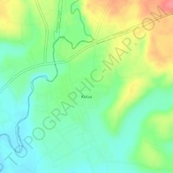
Name: Kutus topographic map, elevation, terrain.

Location: Kutus, Kirinyaga County, Central Kenya, Kenya (-0.58056 37.31754 -0.56251 37.33263)

Average elevation: 1,285 m

Minimum elevation: 1,251 m

Maximum elevation: 1,336 m

Other topographic maps

Click on a map to view its topography, its elevation and its terrain.

Mwea

Kenya > Kirinyaga County > Mwea East

Average elevation: 1,194 m

Kirinyaga Central

Kenya > Kirinyaga County

Average elevation: 2,081 m

Kerugoya

Kenya > Kirinyaga County > Kirinyaga Central

Average elevation: 1,552 m

Gear up for your next adventure:

🥾Waterproof Trail Shoes - Shoes designed to handle wet terrain
🦟Insect Repellent - Keep mosquitoes and black flies away in wooded areas
🏃Hydration Running Vest - Carry water and maps close to your body for speed
🦶Anti-Blister Balm - Prevents friction and hotspots during long ascents
🛶Canoe Life Vest - Safety vest for water sports

As an Amazon Associate, this site earns from qualifying purchases at no extra cost to you.