
Busia topographic map
Click on the map to display elevation.
Busia
Busia, Kenya is located in Busia County, approximately 451 kilometres (280 mi), by road, northwest of Nairobi, Kenya's capital and largest city. This location is immediately east of Busia, Uganda. The coordinates of Busia, Kenya are: 00°27'48.0"N, 34°06'19.0"E (Latitude:0.463333; Longitude:34.105278). Busia, Kenya sits at an average elevation of 1,227 metres (4,026 ft), above sea level.
About this map
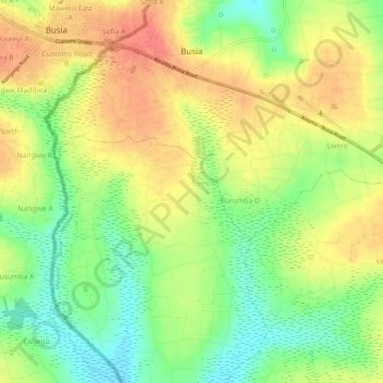
Name: Busia topographic map, elevation, terrain.
Location: Busia, Teso South, Busia County, Western, Kenya (0.41529 34.09681 0.47052 34.15514)
Average elevation: 1,201 m
Minimum elevation: 1,167 m
Maximum elevation: 1,234 m