Geolocate

Machakos topographic map

Click on the map to display elevation.

About this map

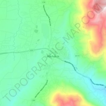
Name: Machakos topographic map, elevation, terrain.

Location: Machakos, Machakos County, East Kenya, Kenya (-1.54563 37.24882 -1.49364 37.28205)

Average elevation: 1,666 m

Minimum elevation: 1,487 m

Maximum elevation: 2,059 m

Gear up for your next adventure:

🛶Canoe Life Vest - Safety vest for water sports
🧭GPS Outdoor Watch - Smart watch for navigation and fitness tracking in nature
💡LED Camping Lantern - Illuminate your campsite with long-lasting lanterns
💧Collapsible Water Bottle - Space-saving water bottle for outdoor activities
🥾Trekking Boots - Durable boots for long-distance trekking

As an Amazon Associate, this site earns from qualifying purchases at no extra cost to you.