
Nandi County topographic map
Click on the map to display elevation.
Nandi County
Nandi county is endowed with a scenic topography that is dotted with numerous tea plantations. These provide the raw material for the county's most vibrant agricultural industry, tea processing.
About this map
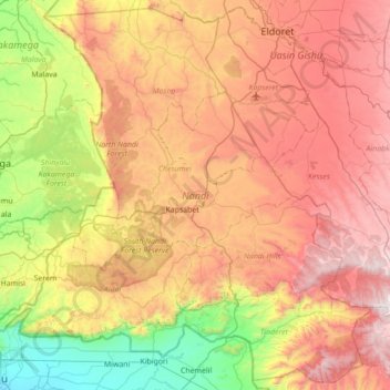
Name: Nandi County topographic map, elevation, terrain.
Location: Nandi County, Rift Valley, Kenya (-0.10975 34.74030 0.56032 35.43891)
Average elevation: 1,887 m
Minimum elevation: 1,140 m
Maximum elevation: 2,755 m
Other topographic maps
Click on a map to view its topography, its elevation and its terrain.
Busia
Kenya > Busia County > Teso South
Busia, Kenya is located in Busia County, approximately 451 kilometres (280 mi), by road, northwest of Nairobi, Kenya's capital and largest city. This location is immediately east of Busia, Uganda. The coordinates of Busia, Kenya are: 00°27'48.0"N, 34°06'19.0"E (Latitude:0.463333; Longitude:34.105278). Busia,…
Average elevation: 1,201 m
Kisumu
The name Kisumu literally means a place of barter trade "sumo". The city has "Friendship" status with Cheltenham, United Kingdom and "sister city" status with Roanoke, Virginia and Boulder, Colorado, United States. Its elevation is 1,131 m (3,711 ft) above sea level. Kisumu is about 320 km (200 mi) northwest…
Average elevation: 1,155 m