
Cooch Behar topographic map
Click on the map to display elevation.
Cooch Behar
Cooch Behar is a flat region with a slight southeastern slope along which the main rivers of the district flow. Most of the highland areas are in the Sitalkuchi region, and most of the low-lying lands lie in Dinhata region. The elevation of the town is 48 meters above mean sea level. The Torsa river flows by the western side of town. The rivers in the district of Cooch Behar generally flow from northwest to southeast. Six rivers that cut through the district are the Teesta, Jaldhaka, Torsha, Kaljani, Raidak, Gadadhar, and Ghargharia.
About this map
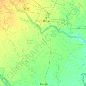
Name: Cooch Behar topographic map, elevation, terrain.
Location: Cooch Behar, Kochbihar, West Bengal, India (26.17501 89.26924 26.33511 89.56484)
Average elevation: 41 m
Minimum elevation: 31 m
Maximum elevation: 53 m
Other topographic maps
Click on a map to view its topography, its elevation and its terrain.
Durgapur
India > West Bengal > Faridpur Durgapur
Durgapur is located at 23°33′N 87°19′E / 23.55°N 87.32°E / 23.55; 87.32. It has an average elevation of 65 metres (213 ft).
Average elevation: 76 m
Maheshtala
India > West Bengal > Thakurpukur Maheshtala
Maheshtala is located at 22°30′31″N 88°15′12″E / 22.5086210°N 88.2532182°E / 22.5086210; 88.2532182. It has an average elevation of 9 metres (30 ft).
Average elevation: 5 m
Bardhaman
India > West Bengal > Burdwan - I
The region has an average elevation of 40 metres (131 ft). The city is situated 1100 km from New Delhi and a little less than 100 km north-west of Kolkata on the Grand Trunk Road (National Highway 19) and Eastern Railway. The chief rivers are the Damodar and the Banka.
Average elevation: 31 m
Siuri
India > West Bengal > Suri - I > Siuri
Suri is located at 23°54′36″N 87°31′37″E / 23.910°N 87.527°E / 23.910; 87.527. Suri is 220 km from State capital Kolkata (Calcutta), 90 km from Durgapur, 34 km from Bolpur–Santiniketan, 55 km from Andal and 19 km from Sainthia on the Andal–Sainthia branch line of Eastern Railway. It is…
Average elevation: 66 m
Naihati
India > West Bengal > Barrackpur - I > Naihati
Naihati is located at 22°54′N 88°25′E / 22.9°N 88.42°E / 22.9; 88.42. It has an average elevation of 15 metres (49 feet).
Average elevation: 9 m
Purulia
India > West Bengal > Purulia - II
Purulia is located at 23°20′N 86°22′E / 23.33°N 86.37°E / 23.33; 86.37. It has an average elevation of 228 metres (748 feet).
Average elevation: 241 m
Ilam Bazar
India > West Bengal > Illambazar > Ilam Bazar
Ilambazar is located at 23°38′N 87°32′E / 23.63°N 87.53°E / 23.63; 87.53. It has an average elevation of 54 m (177 ft).
Average elevation: 58 m
Singur
India > West Bengal > Singur > Singur
Singur is located at 22°49′N 88°14′E / 22.81°N 88.23°E / 22.81; 88.23. It has an average elevation of 14 metres (45 ft), and is situated on the Ganges delta.
Average elevation: 9 m