
Make a donation
Gear up for your next adventure:
As an Amazon Associate, this site earns from qualifying purchases at no extra cost to you.
Purulia topographic map
Click on the map to display elevation.
Make a donation
Gear up for your next adventure:
As an Amazon Associate, this site earns from qualifying purchases at no extra cost to you.
Purulia
Several rivers flow across Purulia district. Among these Kangsabati, Kumari, Silabati (silai), Dwarakeswar, Subarnarekha and Damodar are the important ones. Although several rivers flows across the district, 50% of the water run off due to the undulated topography. There are also several Small dams like Futiyary, Murguma, Pardi, Burda, Gopalpur, which are mainly used for irrigation of agriculture field. Saheb Bandh is one of the popular and famous waterbodies of Purulia. It is located in the heart of the purulia town. It is a shelter of the migratory birds which comes from Bangladesh, Burma, Sindh, Baluchistan during December to March.
Make a donation
Gear up for your next adventure:
As an Amazon Associate, this site earns from qualifying purchases at no extra cost to you.
About this map
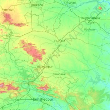
Name: Purulia topographic map, elevation, terrain.
Location: Purulia, West Bengal, India (22.70500 85.81967 23.69920 86.90633)
Average elevation: 225 m
Minimum elevation: 86 m
Maximum elevation: 891 m
Make a donation
Gear up for your next adventure:
As an Amazon Associate, this site earns from qualifying purchases at no extra cost to you.
Other topographic maps
Click on a map to view its topography, its elevation and its terrain.
Durgapur
India > West Bengal > Faridpur Durgapur
Durgapur is located at 23°33′N 87°19′E / 23.55°N 87.32°E / 23.55; 87.32. It has an average elevation of 65 metres (213 ft).
Average elevation: 76 m
Make a donation
Gear up for your next adventure:
As an Amazon Associate, this site earns from qualifying purchases at no extra cost to you.
Maheshtala
India > West Bengal > Thakurpukur Maheshtala
Maheshtala is located at 22°30′31″N 88°15′12″E / 22.5086210°N 88.2532182°E / 22.5086210; 88.2532182. It has an average elevation of 9 metres (30 ft).
Average elevation: 5 m
Bardhaman
India > West Bengal > Burdwan - I
The region has an average elevation of 40 metres (131 ft). The city is situated 1100 km from New Delhi and a little less than 100 km north-west of Kolkata on the Grand Trunk Road (National Highway 19) and Eastern Railway. The chief rivers are the Damodar and the Banka.
Average elevation: 31 m
Make a donation
Gear up for your next adventure:
As an Amazon Associate, this site earns from qualifying purchases at no extra cost to you.
Make a donation
Gear up for your next adventure:
As an Amazon Associate, this site earns from qualifying purchases at no extra cost to you.
Naihati
India > West Bengal > Barrackpur - I > Naihati
Naihati is located at 22°54′N 88°25′E / 22.9°N 88.42°E / 22.9; 88.42. It has an average elevation of 15 metres (49 feet).
Average elevation: 9 m
Purulia
India > West Bengal > Purulia - II
Purulia is located at 23°20′N 86°22′E / 23.33°N 86.37°E / 23.33; 86.37. It has an average elevation of 228 metres (748 feet).
Average elevation: 241 m
Siuri
India > West Bengal > Suri - I > Siuri
Suri is located at 23°54′36″N 87°31′37″E / 23.910°N 87.527°E / 23.910; 87.527. Suri is 220 km from State capital Kolkata (Calcutta), 90 km from Durgapur, 34 km from Bolpur–Santiniketan, 55 km from Andal and 19 km from Sainthia on the Andal–Sainthia branch line of Eastern Railway. It is…
Average elevation: 66 m
Make a donation
Gear up for your next adventure:
As an Amazon Associate, this site earns from qualifying purchases at no extra cost to you.
Ilam Bazar
India > West Bengal > Illambazar > Ilam Bazar
Ilambazar is located at 23°38′N 87°32′E / 23.63°N 87.53°E / 23.63; 87.53. It has an average elevation of 54 m (177 ft).
Average elevation: 58 m
Make a donation
Gear up for your next adventure:
As an Amazon Associate, this site earns from qualifying purchases at no extra cost to you.
Singur
India > West Bengal > Singur > Singur
Singur is located at 22°49′N 88°14′E / 22.81°N 88.23°E / 22.81; 88.23. It has an average elevation of 14 metres (45 ft), and is situated on the Ganges delta.
Average elevation: 9 m