
Make a donation
Gear up for your next adventure:
As an Amazon Associate, this site earns from qualifying purchases at no extra cost to you.
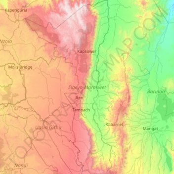
Elgeyo-Marakwet County topographic map
Click on the map to display elevation.
Make a donation
Gear up for your next adventure:
As an Amazon Associate, this site earns from qualifying purchases at no extra cost to you.
Elgeyo-Marakwet County
The Kerio River binds the county on the eastern side. From its alluvial plain the topography gradually rises towards the west. The Elgeyo Escarpment stands out distinctly and causes elevation differences of up to 1,500 m. In the northern and southern part of the county the topography is rugged, giving way to more subdued relief differences going westwards. The underlying geology mainly consists of gneisses from the Basement System. The Cherangany Hills rise gently to form the western half of the Great Rift Valley and extend northwest in a broken chain to Mount Moroto in Uganda. Non-volcanic in origin, the Cherangany Hills resulted from subsequent erosion of the raised western ridge of the Eastern Rift Valley. The range is approximately 30 miles (48 km) long and 25 miles (40 km) wide and averages 9,000 feet (2,700 metres) in height; its highest point reaches more than 11,000 feet (3,400 metres). Many of the summits are covered with huge groundsels and lobelias. Some of the hills include Kameleogon (3581 m), Chebon (3375 m), Chepkotet (3370 m), Alaleigelat (3350 m) and Sodang (3211 m).
Make a donation
Gear up for your next adventure:
As an Amazon Associate, this site earns from qualifying purchases at no extra cost to you.
About this map
Name: Elgeyo-Marakwet County topographic map, elevation, terrain.
Location: Elgeyo-Marakwet County, Rift Valley, Kenya (0.16787 35.15229 1.31682 35.72309)
Average elevation: 1,730 m
Minimum elevation: 675 m
Maximum elevation: 3,506 m
Make a donation
Gear up for your next adventure:
As an Amazon Associate, this site earns from qualifying purchases at no extra cost to you.
Other topographic maps
Click on a map to view its topography, its elevation and its terrain.
Busia
Kenya > Busia County > Teso South
Busia, Kenya is located in Busia County, approximately 451 kilometres (280 mi), by road, northwest of Nairobi, Kenya's capital and largest city. This location is immediately east of Busia, Uganda. The coordinates of Busia, Kenya are: 00°27'48.0"N, 34°06'19.0"E (Latitude:0.463333; Longitude:34.105278). Busia,…
Average elevation: 1,201 m
Make a donation
Gear up for your next adventure:
As an Amazon Associate, this site earns from qualifying purchases at no extra cost to you.
Make a donation
Gear up for your next adventure:
As an Amazon Associate, this site earns from qualifying purchases at no extra cost to you.
Make a donation
Gear up for your next adventure:
As an Amazon Associate, this site earns from qualifying purchases at no extra cost to you.
Kisumu
The name Kisumu literally means a place of barter trade "sumo". The city has "Friendship" status with Cheltenham, United Kingdom and "sister city" status with Roanoke, Virginia and Boulder, Colorado, United States. Its elevation is 1,131 m (3,711 ft) above sea level. Kisumu is about 320 km (200 mi) northwest…
Average elevation: 1,155 m
Make a donation
Gear up for your next adventure:
As an Amazon Associate, this site earns from qualifying purchases at no extra cost to you.
Make a donation
Gear up for your next adventure:
As an Amazon Associate, this site earns from qualifying purchases at no extra cost to you.
Make a donation
Gear up for your next adventure:
As an Amazon Associate, this site earns from qualifying purchases at no extra cost to you.