Geolocate

Pontiac topographic map

Click on the map to display elevation.

About this map

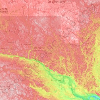
Name: Pontiac topographic map, elevation, terrain.

Location: Pontiac, Outaouais, Quebec, Canada (45.45678 -77.93161 47.28922 -76.14891)

Average elevation: 311 m

Minimum elevation: 54 m

Maximum elevation: 559 m

Quebec trails, hiking, mountain biking, running and outdoor activities

Other topographic maps

Click on a map to view its topography, its elevation and its terrain.

Terrebonne

Canada > Quebec > Terrebonne > Terrebonne

Average elevation: 34 m

Mont Rigaud

Canada > Quebec > Rigaud

Average elevation: 181 m

Mount Royal

Canada > Quebec > Urban agglomeration of Montreal > Montreal

The hill is part of the Monteregian Hills situated between the Laurentians and the Appalachian Mountains. It gave its Latin name, Mons Regius, to the Monteregian chain. The hill consists of three peaks: Colline de la Croix (or Mont Royal proper) at 233 m (764 ft), Colline d'Outremont (or Mount Murray, in the…

Average elevation: 111 m

Lac-Simon

Canada > Quebec

Average elevation: 321 m

Manawan

Canada > Quebec

Average elevation: 455 m

La Grande Rivière

Canada > Quebec

Average elevation: 489 m

Desmaraisville

Canada > Quebec

Average elevation: 315 m

Monts Otish

Canada > Quebec

Average elevation: 924 m

Le Petit Cap

Canada > Quebec

Average elevation: 11 m

Lac Clair

Canada > Quebec

Average elevation: 338 m

L'Île-Saint-Régis

Canada > Quebec

Average elevation: 49 m

Quebec

Canada > Quebec > Urban agglomeration of Québec

Quebec City was built on the north bank of the Saint Lawrence River, where it narrows and meets the mouth of the Saint-Charles River. Old Quebec is located on top and at the foot of Cap-Diamant, which is on the eastern edge of a plateau called the promontory of Quebec (Quebec hill). Because of this topographic…

Average elevation: 100 m

Riceburg

Canada > Quebec > Brome-Missisquoi > Stanbridge East

Average elevation: 78 m

Lac Nantel

Canada > Quebec > Jamésie > Eeyou Istchee James Bay

Average elevation: 271 m

Mont Ham

Canada > Quebec > Les Sources > Ham-Sud

Average elevation: 430 m

Calumet

Canada > Quebec > Argenteuil > Grenville-sur-la-Rouge

Average elevation: 95 m

Mont Orford

Canada > Quebec > Memphrémagog > Orford

Average elevation: 559 m

Quyon

Canada > Quebec > Les Collines-de-l'Outaouais > Pontiac

Average elevation: 78 m

Lac Doug

Canada > Quebec > Manicouagan > Rivière-aux-Outardes

Average elevation: 342 m

Lac Doux

Canada > Quebec > Les Collines-de-l'Outaouais > Cantley

Average elevation: 212 m

Mont Gosford

Canada > Quebec > Le Granit > Saint-Augustin-de-Woburn

Since 1978, Mount Gosford is included in "ZEC Louise-Gosford", a controlled harvesting zone open to the public. Recently, the areas at more than 700 metres of altitude were designated Important Bird Areas due to the presence Bicknell's thrushes, an endemic species living in mountain peaks of northeast North…

Average elevation: 933 m

Mont Owl's Head

Canada > Quebec > Memphrémagog > Potton

Average elevation: 370 m

Notre Dame Mountains

Canada > Quebec > La Haute-Gaspésie > Mont-Albert

The Chic-Choc Mountains are one of the primary subranges of the Notre Dame Mountains. They are located in the northeastern part of the Gaspé Peninsula and are home to the tallest mountain in the range, Mont Jacques-Cartier, with an elevation of 1,268 m (4,160 ft). The other major subsection of the Notre Dame…

Average elevation: 1,128 m

Restigouche River

Canada > Quebec > Avignon > Matapédia

Average elevation: 75 m

Richmond Gulf

Canada > Quebec > Kativik > Baie-d'Hudson

The topography of Lake Tasuijaq is the consequence of two geological faults running parallel to the coast. The resulting dislocation has given rise to the cliffs that dominate the western shore of the lake.

Average elevation: 0 m

Saguenay

Canada > Quebec > Ville de Saguenay

Average elevation: 150 m

Gaspésie

Canada > Quebec > La Haute-Gaspésie > Mont-Albert

Average elevation: 459 m

Joliette

Canada > Quebec > Joliette

Average elevation: 67 m

Le Bout-de-l'Île

Canada > Quebec > Lac-Saint-Jean-Est > Alma

Average elevation: 104 m

Pointe Décarie

Canada > Quebec > Les Laurentides > La Minerve

Average elevation: 328 m

Roggan River

Canada > Quebec > Eeyou Istchee

Average elevation: 8 m

Lac MacLeod

Canada > Quebec > Argenteuil > Harrington

Average elevation: 290 m

Lac Chevreuil

Canada > Quebec > Le Fjord-du-Saguenay > Mont-Valin

Average elevation: 778 m

Sand Bay

Canada > Quebec > Pontiac > Clarendon

Average elevation: 85 m

Rollet

Canada > Quebec > Rouyn-Noranda

Average elevation: 276 m

Lac Mooney

Canada > Quebec > Matawinie > Chertsey

Average elevation: 365 m

Mont Comi

Canada > Quebec > La Mitis > Saint-Donat

Average elevation: 420 m

Lac Windfall

Canada > Quebec > Jamésie > Eeyou Istchee James Bay

Average elevation: 407 m

Lac Weller

Canada > Quebec > Portneuf (MRC) > Saint-Ubalde

Average elevation: 158 m

Luskville

Canada > Quebec > Les Collines-de-l'Outaouais > Pontiac

Average elevation: 131 m

Shawville

Canada > Quebec > Pontiac

Average elevation: 170 m

Mont Boisjoli

Canada > Quebec > Memphrémagog > Hatley (Canton)

Average elevation: 267 m

Lac Rueckwald

Canada > Quebec > Pontiac > Thorne

Average elevation: 223 m

Lac Bitobi

Canada > Quebec > Gracefield

Average elevation: 163 m

Chutes Lockbow

Canada > Quebec > Papineau > Chénéville

Average elevation: 229 m

Pink Lake

Canada > Quebec > Gatineau

Average elevation: 153 m

Lac Beauvais

Canada > Quebec > Les Laurentides > Val-Morin

Average elevation: 439 m

Lac-Pemichangan

Canada > Quebec > Gracefield

Average elevation: 186 m

Marsboro

Canada > Quebec > Le Granit > Marston

Average elevation: 441 m

La Mauricie National Park

Canada > Quebec > Shawinigan

Average elevation: 384 m

Lac Pomponne

Canada > Quebec > Pontiac > Lac-Nilgaut

Average elevation: 347 m

Lac d'Ours

Canada > Quebec > Pontiac > Litchfield

Average elevation: 239 m

Rivière Chateauguay

Canada > Quebec > Châteauguay

Average elevation: 23 m

Lac Bourque

Canada > Quebec > Manicouagan > Franquelin

Average elevation: 165 m

Lac Gale

Canada > Quebec > Brome-Missisquoi > Bromont

Average elevation: 193 m

Matane-Est

Canada > Quebec > La Matanie > Matane

Average elevation: 81 m

Lac Fiddler

Canada > Quebec > Argenteuil > Mille-Isles

Average elevation: 350 m

Lac Prévost

Canada > Quebec > Antoine-Labelle > Lac-Ernest

Average elevation: 369 m

Gear up for your next adventure:

🥾Hiking Shoes - Durable and comfortable shoes for trail hiking
🧴First Aid Kit - Essential first aid supplies for outdoor emergencies
🧥Waterproof Hiking Jacket - Protect yourself from rain and wind while hiking
💡LED Camping Lantern - Illuminate your campsite with long-lasting lanterns
🧼Travel Hand Sanitizer - Keep hands clean when water is scarce

As an Amazon Associate, this site earns from qualifying purchases at no extra cost to you.