Geolocate

Pink Lake topographic map

Interactive map

Click on the map to display elevation.

About this map

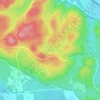
Name: Pink Lake topographic map, elevation, terrain.

Location: Pink Lake, Aylmer, Gatineau, Outaouais, Quebec, Canada (45.46678 -75.81115 45.47000 -75.80219)

Average elevation: 153 m

Minimum elevation: 105 m

Maximum elevation: 216 m

Other topographic maps

Click on a map to view its topography, its elevation and its terrain.

Aylmer

Canada > Quebec > Gatineau

Aylmer, Gatineau, Outaouais, Quebec, Canada

Average elevation: 99 m

Hull

Canada > Quebec > Gatineau

Hull, Gatineau, Outaouais, Quebec, Canada

Average elevation: 66 m

Gatineau

Canada > Quebec > Gatineau

Gatineau, Outaouais, Quebec, Canada

Average elevation: 107 m

Buckingham

Canada > Quebec > Gatineau

Buckingham, Gatineau, Outaouais, Quebec, Canada

Average elevation: 124 m

Parc La Vérendrye

Canada > Quebec > Gatineau

Parc La Vérendrye, 730, Gatineau, Gatineau (ville), Outaouais, Quebec, J8R 1S4, Canada

Average elevation: 89 m