Geolocate

Rollet topographic map

Click on the map to display elevation.

About this map

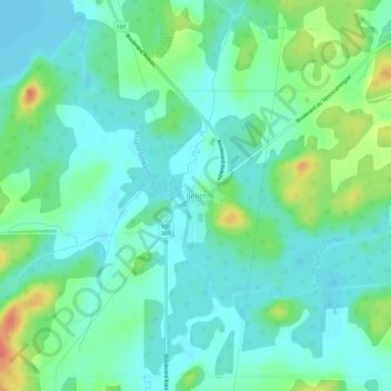
Name: Rollet topographic map, elevation, terrain.

Location: Rollet, Rouyn-Noranda, Abitibi-Témiscamingue, Quebec, Canada (47.89373 -79.26459 47.93373 -79.22459)

Average elevation: 276 m

Minimum elevation: 262 m

Maximum elevation: 310 m

Quebec trails, hiking, mountain biking, running and outdoor activities

Other topographic maps

Click on a map to view its topography, its elevation and its terrain.

Noranda

Canada > Quebec > Rouyn-Noranda

Average elevation: 301 m

D'Alembert

Canada > Quebec > Rouyn-Noranda

Average elevation: 307 m

Lac Brunet

Canada > Quebec > Rouyn-Noranda

Average elevation: 391 m

Gear up for your next adventure:

🛌Down Sleeping Bag - Superior warmth-to-weight ratio for cold nights
🦶Anti-Blister Balm - Prevents friction and hotspots during long ascents
🥾Light Hiking Boots - Lightweight and comfortable boots for day hikes
🥾Mountain Trail Shoes - High-traction shoes for mountain trails
🥾All-Terrain Hiking Boots - Versatile boots for varied hiking conditions

As an Amazon Associate, this site earns from qualifying purchases at no extra cost to you.