
Mount Katmai topographic map
Interactive map
Click on the map to display elevation.
About this map
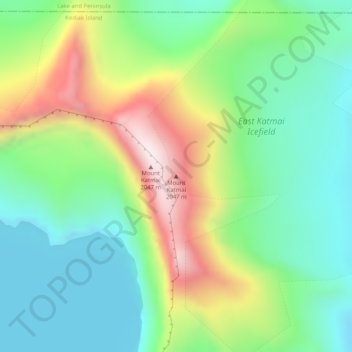
Name: Mount Katmai topographic map, elevation, terrain.
Location: Mount Katmai, Kodiak Island, Alaska, United States (58.27810 -154.94965 58.27820 -154.94955)
Average elevation: 1,507 m
Minimum elevation: 1,269 m
Maximum elevation: 1,968 m
Mount Katmai (Russian: Катмай) is a large stratovolcano (composite volcano) on the Alaska Peninsula in southern Alaska, located within Katmai National Park and Preserve. It is about 6.3 miles (10 km) in diameter with a central lake-filled caldera about two by three miles (3.2 by 4.8 km) in size, formed during the Novarupta eruption of 1912. The caldera rim reaches a maximum elevation of 6,716 feet (2,047 m). In 1975 the surface of the crater lake was at an elevation of about 4,220 feet (1,286 m), and the estimated elevation of the caldera floor is about 3,400 ft (1,040 m). The mountain is located in Kodiak Island Borough, very close to its border with Lake and Peninsula Borough.
Other topographic maps
Click on a map to view its topography, its elevation and its terrain.
Healy
United States > Alaska > Denali
Healy, Denali, Alaska, 99743, United States
Average elevation: 484 m
Chum Lake
United States > Alaska > Kenai Peninsula
Chum Lake, Kenai Peninsula, Alaska, United States
Average elevation: 86 m
Nikolski
United States > Alaska > Aleutians West Census Area
Nikolski, Aleutians West Census Area, Alaska, 99638, United States
Average elevation: 107 m
Sunrise Terrace
United States > Alaska > Anchorage
Sunrise Terrace, Anchorage, Alaska, United States
Average elevation: 22 m
Big Mink Lake
United States > Alaska > Kenai Peninsula
Big Mink Lake, Kenai Peninsula, Alaska, United States
Average elevation: 68 m
Kake
United States > Alaska > Petersburg Borough > Kake
Kake, Petersburg Borough, Alaska, 99830, United States
Average elevation: 35 m
Fort Greely
United States > Alaska > Unorganized Borough
Fort Greely, Unorganized Borough, Alaska, 99731, United States
Average elevation: 580 m
Copper Center
United States > Alaska > Unorganized Borough
Copper Center, Unorganized Borough, Alaska, United States
Average elevation: 400 m
Fairbanks
United States > Alaska > Fairbanks North Star
Fairbanks, Fairbanks North Star, Alaska, United States
Average elevation: 147 m
Eldorado Creek
United States > Alaska > Unorganized Borough
Eldorado Creek, Unorganized Borough, Alaska, United States
Average elevation: 16 m
Echo Mountain
United States > Alaska > Juneau
Echo Mountain, Juneau, Alaska, United States
Average elevation: 1,375 m
The Foothills
United States > Alaska > Anchorage
The Foothills, Anchorage, Alaska, United States
Average elevation: 89 m
Homer
United States > Alaska > Kenai Peninsula
Homer, Kenai Peninsula, Alaska, United States
Average elevation: 103 m
Lime Village
United States > Alaska > Unorganized Borough
Lime Village, Unorganized Borough, Alaska, United States
Average elevation: 179 m
Glacier View
United States > Alaska > Matanuska-Susitna
Glacier View, Matanuska-Susitna, Alaska, United States
Average elevation: 1,127 m
Hubbard Glacier
United States > Alaska > Yakutat
Hubbard Glacier, Yakutat, Alaska, United States
Average elevation: 1,892 m
Link Island
United States > Alaska > Unorganized Borough
Link Island, Unorganized Borough, Alaska, United States
Average elevation: 8 m
Triangle Island
United States > Alaska > Lake and Peninsula
Triangle Island, Lake and Peninsula, Alaska, United States
Average elevation: 14 m
Delta Junction
United States > Alaska > Unorganized Borough
Delta Junction, Unorganized Borough, Alaska, United States
Average elevation: 373 m
Lindeman Lake
United States > Alaska > Unorganized Borough > Thorne Bay
Lindeman Lake, Thorne Bay, Unorganized Borough, Alaska, United States
Average elevation: 68 m
Edge Mountain
United States > Alaska > Kodiak Island
Edge Mountain, Kodiak Island, Alaska, United States
Average elevation: 273 m
Dyea Point
United States > Alaska > Skagway > Skagway
Dyea Point, Skagway, Alaska, 99840, United States
Average elevation: 49 m
Nation River
United States > Alaska > Unorganized Borough
Nation River, Unorganized Borough, Alaska, United States
Average elevation: 301 m
Houston
United States > Alaska > Matanuska-Susitna
Houston, Matanuska-Susitna, Alaska, 99694, United States
Average elevation: 78 m
Botanical Gardens
United States > Alaska > Anchorage
Botanical Gardens, Anchorage, Alaska, United States
Average elevation: 28 m
Mount Douglas
United States > Alaska > Kenai Peninsula
Mount Douglas, Kenai Peninsula, Alaska, United States
Average elevation: 1,695 m
Windy Ridge
United States > Alaska > Unorganized Borough
Windy Ridge, Unorganized Borough, Alaska, United States
Average elevation: 101 m
Oliktok Point
United States > Alaska > North Slope
Oliktok Point, North Slope, Alaska, United States
Average elevation: 0 m
Cantwell
United States > Alaska > Denali
Cantwell, Denali, Alaska, 99729, United States
Average elevation: 1,104 m
King Salmon
United States > Alaska > Bristol Bay
King Salmon, Bristol Bay, Alaska, United States
Average elevation: 54 m
Tok
United States > Alaska > Unorganized Borough
Tok, Unorganized Borough, Alaska, 99780, United States
Average elevation: 559 m
Rampart
United States > Alaska > Unorganized Borough
Rampart, Unorganized Borough, Alaska, 99767, United States
Average elevation: 532 m
Footprint Lake
United States > Alaska > North Slope > Utqiaġvik
Footprint Lake, Utqiaġvik, North Slope, Alaska, United States
Average elevation: 8 m
Kenai
United States > Alaska > Kenai Peninsula
Kenai, Kenai Peninsula, Alaska, United States
Average elevation: 16 m
Southeast Fairbanks (CA)
Southeast Fairbanks (CA), Alaska, United States
Average elevation: 890 m
Red Mountain
United States > Alaska > Denali
Red Mountain, Denali, Alaska, United States
Average elevation: 1,708 m
San Juan Islands
United States > Alaska > Unorganized Borough
San Juan Islands, Unorganized Borough, Alaska, United States
Average elevation: 4 m
Kupreanof Island
Kupreanof Island, Alaska, 99830, United States
Average elevation: 128 m
Marten River
United States > Alaska > Ketchikan Gateway
Marten River, Ketchikan Gateway, Alaska, United States
Average elevation: 207 m
Sheep River
United States > Alaska > Matanuska-Susitna
Sheep River, Matanuska-Susitna, Alaska, United States
Average elevation: 1,028 m
Wiseman
United States > Alaska > Unorganized Borough
Wiseman, Unorganized Borough, Alaska, United States
Average elevation: 760 m
Indian River Falls
United States > Alaska > Sitka > Sitka
Indian River Falls, Sitka, Alaska, United States
Average elevation: 540 m
Ketchikan
United States > Alaska > Ketchikan Gateway > Ketchikan
Ketchikan, Ketchikan Gateway, Alaska, 99901, United States
Average elevation: 149 m
Denali's Fault. Scenic overlook
United States > Alaska > Unorganized Borough > Delta Junction
Denali's Fault. Scenic overlook, Richardson Highway, Delta Junction, Unorganized Borough, Alaska, 99731, United States
Average elevation: 379 m