
Copper Center topographic map
Click on the map to display elevation.
About this map
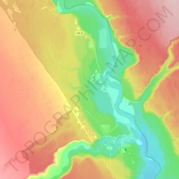
Name: Copper Center topographic map, elevation, terrain.
Location: Copper Center, Unorganized Borough, Alaska, United States (61.93096 -145.44418 62.03247 -145.26563)
Average elevation: 400 m
Minimum elevation: 298 m
Maximum elevation: 506 m
Other topographic maps
Click on a map to view its topography, its elevation and its terrain.
Adak
United States > Alaska > Unorganized Borough
Because of its naval aviation past, Adak has an unusually large and sophisticated airport for the Aleutian Islands. The airport is currently operated by the State of Alaska Department of Transportation. Complete with an Instrument Landing System, Adak Airport has no control tower and two 200 ft (61 m) wide…
Average elevation: 136 m
Paxson
United States > Alaska > Unorganized Borough
Paxson has a continental subarctic climate (Köppen Dfc), closely bordering on an alpine climate (Köppen ET) due to its high elevation and northerly latitude, with only one month above the 50 degree isotherm.
Average elevation: 1,015 m