Geolocate

Fort Greely topographic map

Click on the map to display elevation.

About this map

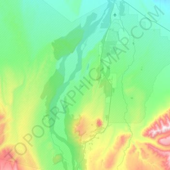
Name: Fort Greely topographic map, elevation, terrain.

Location: Fort Greely, Unorganized Borough, Alaska, 99731, United States (63.68866 -145.98753 64.02600 -145.43381)

Average elevation: 580 m

Minimum elevation: 335 m

Maximum elevation: 1,548 m

Other topographic maps

Click on a map to view its topography, its elevation and its terrain.

Kasatochi Island

United States > Alaska > Unorganized Borough

Kasatochi Island is a member of the Aleutian Islands, which lie above a narrow ridge that separates the Bering Sea from the North Pacific. It lies at the Atka Pass northwest of the western tip of Atka Island and east of Great Sitkin Island. It is at 52.177° N latitude and 175.508° W longitude, with a summit…

Average elevation: 53 m

Medicine

United States > Alaska > Unorganized Borough

Average elevation: 387 m

Angoon

United States > Alaska > Unorganized Borough > Angoon

Average elevation: 38 m

Wiseman

United States > Alaska > Unorganized Borough

Average elevation: 760 m

Rampart

United States > Alaska > Unorganized Borough

Average elevation: 532 m

Tok

United States > Alaska > Unorganized Borough

Average elevation: 559 m

Windy Ridge

United States > Alaska > Unorganized Borough

Average elevation: 101 m

Gear up for your next adventure:

Camping Coffee Maker - Brew fresh coffee anywhere on the topographic map
Lightweight Camping Tent - Portable shelter optimized for Canadian backcountry camping
Tent Footprint - Protect tent floor and increase durability
🧦Hiking Liner Socks - Thin base layer to prevent friction and blisters
🔭Compact Monocular - One-handed bird watching and trail spotting

As an Amazon Associate, this site earns from qualifying purchases at no extra cost to you.