
Zile topographic map
Click on the map to display elevation.
Zile
Zile covers an area of 1,512 square kilometres (584 sq mi) within its city limits and has an elevation of 710 metres (2,330 ft). Turhal, Çekerek, Artova, Kadışehri, and Amasya are all towns located near Zile. The city is mostly surrounded by a fertile plain called Zile Ovası crossed by the Yeşil River and can produce harvests twice a year. South of the city, however, are the Deveci Mountains (1,892 m / 6,207 ft high), Güvercin Çalı, and Hüseyin Gazi Hill. Zile once had a great forest covering most of the plain, but during the 1950s, the city lost much of its forest because of the excessive breeding of goats and the use of wood for heating purposes. However, there is a recent study to plan reforestation in the area.
About this map
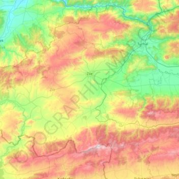
Name: Zile topographic map, elevation, terrain.
Location: Zile, Tokat, Black Sea Region, 60400, Turkey (40.05922 35.43958 40.44936 36.11907)
Average elevation: 985 m
Minimum elevation: 423 m
Maximum elevation: 1,897 m
Other topographic maps
Click on a map to view its topography, its elevation and its terrain.