
Thank you for supporting this site ❤️
Make a donation
Make a donation
Gear up for your next adventure:
As an Amazon Associate, this site earns from qualifying purchases at no extra cost to you.
Şehitkamil topographic map
Click on the map to display elevation.
Thank you for supporting this site ❤️
Make a donation
Make a donation
Gear up for your next adventure:
As an Amazon Associate, this site earns from qualifying purchases at no extra cost to you.
About this map
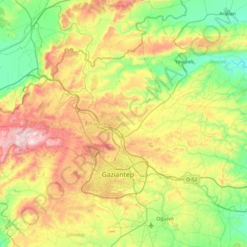
Name: Şehitkamil topographic map, elevation, terrain.
Location: Şehitkamil, Gaziantep, Southeastern Anatolia Region, Turkey (36.99508 37.00558 37.37076 37.70454)
Average elevation: 821 m
Minimum elevation: 497 m
Maximum elevation: 1,470 m
Thank you for supporting this site ❤️
Make a donation
Make a donation
Gear up for your next adventure:
As an Amazon Associate, this site earns from qualifying purchases at no extra cost to you.