
Saba topographic map
Interactive map
Click on the map to display elevation.
About this map
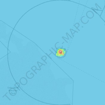
Name: Saba topographic map, elevation, terrain.
Location: Saba, Netherlands (17.41400 -63.46882 17.85000 -63.02603)
Average elevation: 2 m
Minimum elevation: 0 m
Maximum elevation: 834 m
There is an 8.6 hectares (21 acres) cloud forest located at and above 825 metres (2,707 ft) on top of the mountain referred to as the "Elfin Forest Reserve" because of its high altitude mist and mossy appearance. The most dominant tree in the cloud forest is the Mountain Mahogany (Freziera undulate), although hurricanes over the years have destroyed a large number of the mature trees. Despite the name, the mountain mahogany is not related to other mahogany species; although one species of true mahogany tree is found on the island at lower levels, the small-leaved mahogany (Swietenia mahagoni). In the underbrush of the mahogany trees, the Sierran palm (Prestoea montana) and tree ferns dominate, with a large variety of epiphytes and Orchids growing on the trunks and branches of all the trees. Wild raspberries and plantain trees can also be found growing on most of the mountain. All seven of the Lesser Antilles Endemic Bird Area restricted-range birds occur in the Elfin Forest Reserve.
Other topographic maps
Click on a map to view its topography, its elevation and its terrain.
's-Hertogenbosch
's-Hertogenbosch, North Brabant, Netherlands
Average elevation: 4 m
Schellingwoude
Netherlands > North Holland > Amsterdam
Schellingwoude, Amsterdam, North Holland, Netherlands, 1023 NH, Netherlands
Average elevation: 1 m
Oosterwijzend
Netherlands > North Holland > Hoogkarspel
Oosterwijzend, Hoogkarspel, Drechterland, North Holland, Netherlands, 1616 CN, Netherlands
Average elevation: -2 m
Zuidbarge
Netherlands > Drenthe > Emmen
Zuidbarge, Emmen, Drenthe, Netherlands, 7825 TS, Netherlands
Average elevation: 20 m
Oud-Zevenaar
Netherlands > Gelderland > Zevenaar
Oud-Zevenaar, Zevenaar, Gelderland, Netherlands, 6905 AJ, Netherlands
Average elevation: 12 m
Purmerend
Netherlands > North Holland > Purmerend
Purmerend, North Holland, Netherlands
Average elevation: -2 m
Dutch Harbour
Netherlands > South Holland > 's-Gravendeel
Dutch Harbour, 's-Gravendeel, Hoeksche Waard, South Holland, Netherlands, 3295 XZ, Netherlands
Average elevation: 1 m
Hout
Netherlands > North Brabant > Geldrop
Hout, Geldrop, Geldrop-Mierlo, North Brabant, Netherlands, 5664 EW, Netherlands
Average elevation: 22 m
Den Burg
Den Burg, Texel, North Holland, Netherlands
Average elevation: 1 m
Zevenhuizen
Zevenhuizen, Zuidplas, South Holland, Netherlands
Average elevation: -4 m
Hillegom
Netherlands > South Holland > Hillegom
Hillegom, South Holland, Netherlands
Average elevation: 0 m
Helvoirt
Helvoirt, Vught, North Brabant, Netherlands
Average elevation: 7 m
Amsterdam
Netherlands > North Holland > Amsterdam
Amsterdam, North Holland, Netherlands, 1012JS, Netherlands
Average elevation: -1 m
Sint Anthonis
Sint Anthonis, Land van Cuijk, North Brabant, Netherlands
Average elevation: 18 m
Capelle aan den IJssel
Capelle aan den IJssel, South Holland, Netherlands
Average elevation: -1 m
Leeward Islands
Leeward Islands, Zion's Hill, Saba, Netherlands
Average elevation: 112 m
Groningen
Netherlands > Groningen > Groningen
Groningen, Netherlands, 9712HS, Netherlands
Average elevation: 2 m
Zwijndrecht
Netherlands > South Holland > Zwijndrecht
Zwijndrecht, South Holland, Netherlands
Average elevation: 1 m
Eindhoven
Netherlands > North Brabant > Eindhoven
Eindhoven, North Brabant, Netherlands, 5611EB, Netherlands
Average elevation: 21 m
Zandvoort
Netherlands > North Holland > Zandvoort
Zandvoort, North Holland, Netherlands
Average elevation: 4 m
Eemshaven
Netherlands > Groningen > Eemshaven
Eemshaven, Het Hogeland, Groningen, Netherlands
Average elevation: 0 m
Wageningen
Netherlands > Gelderland > Wageningen
Wageningen, Gelderland, Netherlands
Average elevation: 14 m
Geertruidenberg
Geertruidenberg, North Brabant, Netherlands
Average elevation: 2 m
Roosendaal
Netherlands > North Brabant > Roosendaal
Roosendaal, North Brabant, Netherlands
Average elevation: 5 m
Pernis
Netherlands > South Holland > Pernis
Pernis, Rotterdam, South Holland, Netherlands
Average elevation: 3 m