America topographic map
Interactive map
Click on the map to display elevation.
America topographic map, elevation, terrain
About this map
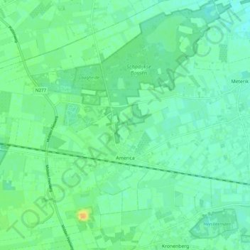
Name: America topographic map, elevation, terrain.
Location: America, Horst aan de Maas, Limburg, Netherlands (51.41890 5.91638 51.47140 6.01373)
Average elevation: 31 m
Minimum elevation: 22 m
Maximum elevation: 50 m
Other topographic maps
Click on a map to view its topography, its elevation and its terrain.
Beek
The municipality of Beek makes part of the region of South Limburg and lies between the city of Geleen in the north and Maastricht in the south, and lies furthermore southeast of interchange Kerensheide and the chemical industries of Chemelot. It has a slightly hilly landscape with altitudes differing between…
Average elevation: 102 m
Heerlen
Netherlands > Limburg > Heerlen
Heerlen's high elevation makes it one of the highest cities above sea level in the Netherlands.
Average elevation: 133 m
Horst aan de Maas
Dutch Topographic map of the municipality of Horst aan de Maas, June 2015.
Average elevation: 27 m