Geolocate

Beek topographic map

Click on the map to display elevation.

About this map

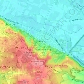
Name: Beek topographic map, elevation, terrain.

Location: Beek, Berg en Dal, Gelderland, Netherlands (51.81634 5.90007 51.84087 5.96290)

Average elevation: 38 m

Minimum elevation: 6 m

Maximum elevation: 95 m

Other topographic maps

Click on a map to view its topography, its elevation and its terrain.

Oud-Zevenaar

Netherlands > Gelderland > Zevenaar

Average elevation: 12 m

Gear up for your next adventure:

🧢Hiking Hat - Sun-protective and breathable hats for long treks
🧢Sun Protection Cap - Breathable cap to protect from sun exposure
🥾Hiking Gaiters - Protect legs and shoes from mud, snow, and debris
🧣Evaporative Cooling Towel - Beat the heat during intense summer climbs
🛶Waterproof Dry Bags - Keep electronics and clothes dry during river crossings

As an Amazon Associate, this site earns from qualifying purchases at no extra cost to you.