
Capelle aan den IJssel topographic map
Interactive map
Click on the map to display elevation.
About this map
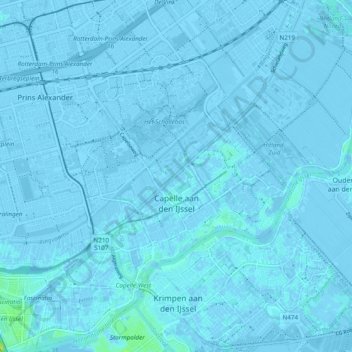
Name: Capelle aan den IJssel topographic map, elevation, terrain.
Location: Capelle aan den IJssel, South Holland, Netherlands (51.90620 4.53716 51.96550 4.61949)
Average elevation: -1 m
Minimum elevation: -7 m
Maximum elevation: 15 m
Dutch Topographic map of the municipality of Capelle aan den IJssel, June 2015.
Other topographic maps
Click on a map to view its topography, its elevation and its terrain.
Dutch Harbour
Netherlands > South Holland > 's-Gravendeel
Dutch Harbour, 's-Gravendeel, Hoeksche Waard, South Holland, Netherlands, 3295 XZ, Netherlands
Average elevation: 1 m
Zevenhuizen
Zevenhuizen, Zuidplas, South Holland, Netherlands
Average elevation: -4 m
Hillegom
Netherlands > South Holland > Hillegom
Hillegom, South Holland, Netherlands
Average elevation: 0 m
Zwijndrecht
Netherlands > South Holland > Zwijndrecht
Zwijndrecht, South Holland, Netherlands
Average elevation: 1 m
Pernis
Netherlands > South Holland > Pernis
Pernis, Rotterdam, South Holland, Netherlands
Average elevation: 3 m
Capelle aan den IJssel
Netherlands > South Holland > Capelle aan den IJssel
Capelle aan den IJssel, South Holland, Netherlands
Average elevation: -1 m
Alblasserdam
Netherlands > South Holland > Alblasserdam
Alblasserdam, South Holland, Netherlands
Average elevation: 1 m
Spijkenisse
Netherlands > South Holland > Spijkenisse
Spijkenisse, Nissewaard, South Holland, Netherlands
Average elevation: 1 m
Ringvaart van de Zuidplaspolder
Netherlands > South Holland > Moordrecht
Ringvaart van de Zuidplaspolder, Moordrecht, Zuidplas, South Holland, Netherlands, 2809ND, Netherlands
Average elevation: -3 m
Dordrecht
Netherlands > South Holland > Dordrecht
Dordrecht, South Holland, Netherlands
Average elevation: 1 m
Zoetermeer
Netherlands > South Holland > Zoetermeer
Zoetermeer, South Holland, Netherlands
Average elevation: -3 m