Geolocate

Gennep topographic map

Interactive map

Click on the map to display elevation.

About this map

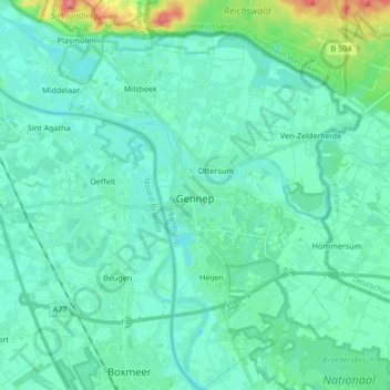
Name: Gennep topographic map, elevation, terrain.

Location: Gennep, Limburg, Netherlands (51.64378 5.91947 51.74802 6.04494)

Average elevation: 16 m

Minimum elevation: 4 m

Maximum elevation: 76 m

Other topographic maps

Click on a map to view its topography, its elevation and its terrain.

America

Netherlands > Limburg

America, Horst aan de Maas, Limburg, Netherlands

Average elevation: 31 m

Born

Netherlands > Limburg

Born, Sittard-Geleen, Limburg, Netherlands

Average elevation: 34 m

Beek

Netherlands > Limburg

Beek, Limburg, Netherlands

Average elevation: 102 m

Roermond

Netherlands > Limburg > Roermond

Roermond, Limburg, Netherlands

Average elevation: 25 m

Maastricht

Netherlands > Limburg > Maastricht

Maastricht, Limburg, Netherlands

Average elevation: 72 m

Heerlen

Netherlands > Limburg > Heerlen

Heerlen, Limburg, Netherlands

Average elevation: 133 m

Heerlen

Netherlands > Limburg > Heerlen

Heerlen, Limburg, Netherlands

Average elevation: 131 m

Horst aan de Maas

Netherlands > Limburg

Horst aan de Maas, Limburg, Netherlands

Average elevation: 27 m

Margraten

Netherlands > Limburg

Margraten, Eijsden-Margraten, Limburg, Netherlands

Average elevation: 156 m