Geolocate

Zandvoort topographic map

Click on the map to display elevation.

About this map

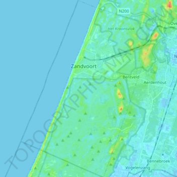
Name: Zandvoort topographic map, elevation, terrain.

Location: Zandvoort, North Holland, Netherlands (52.31400 4.47765 52.40517 4.59166)

Average elevation: 4 m

Minimum elevation: -3 m

Maximum elevation: 40 m

Other topographic maps

Click on a map to view its topography, its elevation and its terrain.

Amsterdam

Netherlands > North Holland > Amsterdam

Average elevation: -1 m

Oosterwijzend

Netherlands > North Holland > Hoogkarspel

Average elevation: -2 m

Gear up for your next adventure:

🧤Rechargeable Heated Gloves - Extreme warmth for Canadian winter expeditions
🧊Portable Cooler - Keep food and drinks cold during outdoor adventures
🧢Outdoor Cap - Protective cap for sun and rain during hikes
🥾Waterproof Hiking Boots - Essential footwear for rugged terrain and wet Canadian trails
🧭Orienteering Kit - Tools for map reading and navigation in the wild

As an Amazon Associate, this site earns from qualifying purchases at no extra cost to you.