Geolocate

Enschede topographic map

Click on the map to display elevation.

About this map

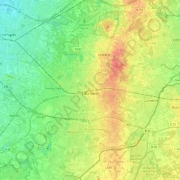
Name: Enschede topographic map, elevation, terrain.

Location: Enschede, Overijssel, Netherlands (52.16121 6.75589 52.28551 6.98110)

Average elevation: 38 m

Minimum elevation: 15 m

Maximum elevation: 69 m

Other topographic maps

Click on a map to view its topography, its elevation and its terrain.

Enschede

Netherlands > Overijssel > Enschede

Average elevation: 34 m

Witteberg

Netherlands > Overijssel

Average elevation: 57 m

Zuurberg

Netherlands > Overijssel > Holten

Average elevation: 17 m

Tankenberg

Netherlands > Overijssel > de Lutte

Average elevation: 58 m

Helhuizen

Netherlands > Overijssel > Holten

Average elevation: 20 m

Usselo

Netherlands > Overijssel > Enschede

Average elevation: 31 m

Frankhuis

Netherlands > Overijssel > Zwolle

Average elevation: 3 m

Gear up for your next adventure:

🔦LED Flashlight - Powerful and long-lasting flashlight for camping and emergencies
🪜Heavy Duty Carabiners - Multi-use clips for securing gear to your backpack
🥾Mountain Trail Shoes - High-traction shoes for mountain trails
🦟Insect Repellent - Keep mosquitoes and black flies away in wooded areas
🚲Heavy Duty Bike Lock - Secure your bike at the trailhead or during stops

As an Amazon Associate, this site earns from qualifying purchases at no extra cost to you.