Geolocate

Zeewolde topographic map

Click on the map to display elevation.

About this map

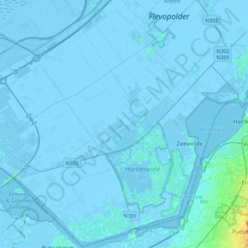
Name: Zeewolde topographic map, elevation, terrain.

Location: Zeewolde, Flevoland, Netherlands (52.24953 5.30124 52.44266 5.62302)

Average elevation: -2 m

Minimum elevation: -9 m

Maximum elevation: 29 m

Gear up for your next adventure:

🎒Backpack Rain Cover - External shield to keep your entire pack dry
🔭Outdoor Binoculars - Lightweight binoculars for birdwatching and hiking
💧Filtered Water Bottle - Safe drinking water on the go
💧Reusable Water Bottle - Durable water bottles for hydration on trails
🥫Freeze-Dried Meals - Lightweight, high-calorie nutrition for multi-day treks

As an Amazon Associate, this site earns from qualifying purchases at no extra cost to you.