
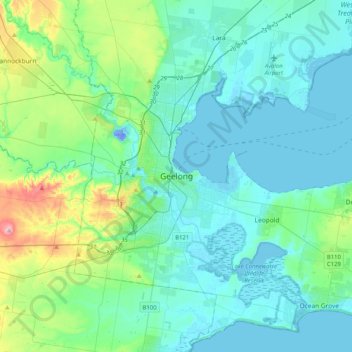
Geelong topographic map
Interactive map
Click on the map to display elevation.
About this map
Name: Geelong topographic map, elevation, terrain.
Average elevation: 42 m
Minimum elevation: -28 m
Maximum elevation: 260 m
Other topographic maps
Click on a map to view its topography, its elevation and its terrain.
Horsham
Horsham's topography is flat, approximately 128 metres (420 ft) above sea level. The central business district (CBD) is laid out in a grid plan south of the train line and is characterised by wide streets and several roundabouts. Firebrace Street, running north–south through the middle of the CBD is one of…
Average elevation: 129 m
Kerang
Kerang is a rural town on the Loddon River in northern Victoria in Australia. It is the commercial centre to an irrigation district based on livestock, horticulture, lucerne and grain. It is located 279 kilometres (173 mi) north-west of Melbourne on the Murray Valley Highway a few kilometres north of its…
Average elevation: 78 m
Narre Warren North Retarding Basin (Melbourne Water)
Australia > Victoria > Melbourne
Average elevation: 76 m
Castlemaine
The Castlemaine goldfields' legendary prosperity raised expectations of Castlemaine becoming Victoria's second city. That is reflected in imposing buildings erected in the town's first few years. Though the rich alluvial diggings were largely exhausted within 15–20 years causing the town's population to…
Average elevation: 319 m
Oakleigh South
Australia > Victoria > Melbourne
A 2005 report called Liveable Melbourne that was commissioned by The Age and conducted by Tract Consultants and ACIL Tasman, ranked Melbourne suburbs and assigned them scores on fourteen characteristics such as crime, CBD proximity, and traffic congestion. The report found that Oakleigh South had a very low…
Average elevation: 55 m
Falls Creek
Australia > Victoria > Falls Creek Alpine Resort
The Falls Creek Alpine Resort is an alpine ski resort in the Hume region in northeastern Victoria, Australia. It is located in the Alpine National Park in the Victorian Alps, approximately 350 kilometres (220 miles) by road from Melbourne, with the nearest town being Mount Beauty, which is approximately 30 km…
Average elevation: 1,459 m
Macedon
Newspaper articles from the late 19th and early 20th century describe the wide variety of plants that flourished at the State Nursery in spite of its poor topsoil and craggy terrain. Cool-climate trees like cypress, larch, cedar and pine thrived at the high altitude; deciduous species of oak, ash and birch…
Average elevation: 542 m
Collingwood
Collingwood's topography is mostly flat, but a prominent slope extends from Hoddle Street up to Smith Street, and also along sections of Hoddle Street.
Average elevation: 30 m
Fitzroy
Australia > Victoria > Melbourne
Fitzroy's topography is flat. It is laid out in grid plan and is characterised by a fairly tightly spaced rectangular grid of medium-sized streets, with many of its narrow streets and back lanes facilitating only one-way traffic. Its built form is a legacy of its early history when a mixture of land uses was…
Average elevation: 35 m