
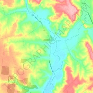
Dunrobin topographic map
Interactive map
Click on the map to display elevation.
About this map
Name: Dunrobin topographic map, elevation, terrain.
Location: Dunrobin, Shire of Glenelg, Victoria, 3312, Australia (-37.55673 141.32576 -37.48025 141.43775)
Average elevation: 105 m
Minimum elevation: 46 m
Maximum elevation: 187 m
Other topographic maps
Click on a map to view its topography, its elevation and its terrain.
Warrenheip
Australia > Victoria > Ballarat
Warrenheip, Ballarat, City of Ballarat, Victoria, Australia
Average elevation: 532 m
Port Campbell
Port Campbell, Shire of Corangamite, Victoria, 3269, Australia
Average elevation: 46 m
Kalimna West
Kalimna West, Shire of East Gippsland, Victoria, 3909, Australia
Average elevation: 71 m
Oakleigh District
Australia > Victoria > Melbourne
Oakleigh District, Melbourne, City of Monash, Victoria, Australia
Average elevation: 69 m
Brimbank Park
Australia > Victoria > Melbourne
Brimbank Park, Keilor East, Melbourne, City of Brimbank, Victoria, 3021, Australia
Average elevation: 52 m
Wandin North
Australia > Victoria > Melbourne
Wandin North, Melbourne, Shire of Yarra Ranges, Victoria, 3139, Australia
Average elevation: 184 m
East Pinnacle
East Pinnacle, Shire of Wellington, Victoria, Australia
Average elevation: 1,099 m
Fawcett Hill
Fawcett Hill, Shire of Central Goldfields, Victoria, Australia
Average elevation: 287 m
Renfew Court Reserve
Australia > Victoria > Melbourne
Renfew Court Reserve, Greenvale, Melbourne, City of Hume, Victoria, 3059, Australia
Average elevation: 131 m
Phillip Island
Australia > Victoria > Ventnor
Phillip Island, Ventnor, Bass Coast Shire, Victoria, 3922, Australia
Average elevation: 5 m
Mount Abrupt
Mount Abrupt, Shire of Southern Grampians, Victoria, 3294, Australia
Average elevation: 422 m
Mount Hotham
Australia > Victoria > Mount Hotham Alpine Resort
Mount Hotham, Mount Hotham Alpine Resort, Victoria, Australia
Average elevation: 1,635 m
Rutherford Park
Rutherford Park, Shire of Hepburn, Victoria, 3364, Australia
Average elevation: 519 m
Porcupine Ridge
Porcupine Ridge, Shire of Hepburn, Victoria, 3461, Australia
Average elevation: 497 m
Port Melbourne Beach
Australia > Victoria > Melbourne
Port Melbourne Beach, Beacon Cove, Port Melbourne, Melbourne, City of Port Phillip, Victoria, 3207, Australia
Average elevation: 3 m
Mount Albert
Mount Albert, Rural City of Benalla, Victoria, Australia
Average elevation: 414 m
Shire of Strathbogie
Shire of Strathbogie, Victoria, Australia
Average elevation: 225 m
Riddells Creek
Riddells Creek, Shire of Macedon Ranges, Victoria, 3431, Australia
Average elevation: 436 m
Melbourne Water Reserve
Australia > Victoria > Melbourne
Melbourne Water Reserve, Ringwood North, Melbourne, City of Manningham, Victoria, Australia
Average elevation: 127 m
Whittlesea
Australia > Victoria > Melbourne
Whittlesea, Melbourne, City of Whittlesea, Victoria, 3757, Australia
Average elevation: 363 m
Fosterville
Fosterville, City of Greater Bendigo, Victoria, 3557, Australia
Average elevation: 176 m
Albert Park District
Australia > Victoria > Melbourne
Albert Park District, Melbourne, City of Port Phillip, Victoria, Australia
Average elevation: 10 m
Observatory Hill
Australia > Victoria > Portland
Observatory Hill, Portland, Shire of Glenelg, Victoria, 3305, Australia
Average elevation: 9 m
Shire of Mansfield
Shire of Mansfield, Victoria, Australia
Average elevation: 748 m
Mount Eliza
Australia > Victoria > Melbourne
Mount Eliza, Melbourne, Shire of Mornington Peninsula, Victoria, 3930, Australia
Average elevation: 60 m
Lake Kennedy Wildlife Reserve (hunting)
Lake Kennedy Wildlife Reserve (hunting), Croxton East, Shire of Southern Grampians, Victoria, Australia
Average elevation: 198 m
Mount Loch
Mount Loch, Alpine Shire, Victoria, Australia
Average elevation: 1,648 m
Rural City of Benalla
Rural City of Benalla, Victoria, Australia
Average elevation: 294 m
Camperdown
Camperdown, Shire of Corangamite, Victoria, 3260, Australia
Average elevation: 165 m
Narre Warren North Retarding Basin (Melbourne Water)
Australia > Victoria > Melbourne
Narre Warren North Retarding Basin (Melbourne Water), Narre Warren North, Melbourne, City of Casey, Victoria, 3804, Australia
Average elevation: 76 m
Melbourne Water Pipe Reserve
Australia > Victoria > Melbourne
Melbourne Water Pipe Reserve, Burwood East, Melbourne, City of Whitehorse, Victoria, Australia
Average elevation: 118 m