Kerang topographic map
Interactive map
Click on the map to display elevation.
About this map
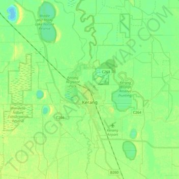
Name: Kerang topographic map, elevation, terrain.
Location: Kerang, Shire of Gannawarra, Victoria, 3579, Australia (-35.78963 143.86118 -35.65858 144.03421)
Average elevation: 78 m
Minimum elevation: 69 m
Maximum elevation: 87 m
Kerang is a rural town on the Loddon River in northern Victoria in Australia. It is the commercial centre to an irrigation district based on livestock, horticulture, lucerne and grain. It is located 279 kilometres (173 mi) north-west of Melbourne on the Murray Valley Highway a few kilometres north of its intersection with the Loddon Valley Highway, elevation 78 metres (256 ft). At the 2016 census, Kerang had a population of 3,893. Kerang is believed to be an Aboriginal word for Cockatoo. It is home to the largest solar and battery farm in the country which was opened in June 2019. The 50-megawatt battery system is located outside of Kerang and stores 100 per cent renewable energy. The 2,000 solar panels have become a tourist attraction and are drawing many businesses to the town.
Other topographic maps
Click on a map to view its topography, its elevation and its terrain.
East Pinnacle
East Pinnacle, Shire of Wellington, Victoria, Australia
Average elevation: 1,099 m
Renfew Court Reserve
Australia > Victoria > Melbourne
Renfew Court Reserve, Greenvale, Melbourne, City of Hume, Victoria, 3059, Australia
Average elevation: 131 m
Fawcett Hill
Fawcett Hill, Shire of Central Goldfields, Victoria, Australia
Average elevation: 287 m
Phillip Island
Australia > Victoria > Ventnor
Phillip Island, Ventnor, Bass Coast Shire, Victoria, 3922, Australia
Average elevation: 5 m
Mount Abrupt
Mount Abrupt, Shire of Southern Grampians, Victoria, 3294, Australia
Average elevation: 422 m
Mount Hotham
Australia > Victoria > Mount Hotham Alpine Resort
Mount Hotham, Mount Hotham Alpine Resort, Victoria, Australia
Average elevation: 1,635 m
Rutherford Park
Rutherford Park, Shire of Hepburn, Victoria, 3364, Australia
Average elevation: 519 m
Porcupine Ridge
Porcupine Ridge, Shire of Hepburn, Victoria, 3461, Australia
Average elevation: 497 m
Port Melbourne Beach
Australia > Victoria > Melbourne
Port Melbourne Beach, Beacon Cove, Port Melbourne, Melbourne, City of Port Phillip, Victoria, 3207, Australia
Average elevation: 3 m
Shire of Strathbogie
Shire of Strathbogie, Victoria, Australia
Average elevation: 225 m
Riddells Creek
Riddells Creek, Shire of Macedon Ranges, Victoria, 3431, Australia
Average elevation: 436 m
Mount Albert
Mount Albert, Rural City of Benalla, Victoria, Australia
Average elevation: 414 m
Whittlesea
Australia > Victoria > Melbourne
Whittlesea, Melbourne, City of Whittlesea, Victoria, 3757, Australia
Average elevation: 363 m
Fosterville
Fosterville, City of Greater Bendigo, Victoria, 3557, Australia
Average elevation: 176 m
Albert Park District
Australia > Victoria > Melbourne
Albert Park District, Melbourne, City of Port Phillip, Victoria, Australia
Average elevation: 10 m
Melbourne Water Reserve
Australia > Victoria > Melbourne
Melbourne Water Reserve, Ringwood North, Melbourne, City of Manningham, Victoria, Australia
Average elevation: 127 m
Observatory Hill
Australia > Victoria > Portland
Observatory Hill, Portland, Shire of Glenelg, Victoria, 3305, Australia
Average elevation: 9 m
Shire of Mansfield
Shire of Mansfield, Victoria, Australia
Average elevation: 748 m
Mount Eliza
Australia > Victoria > Melbourne
Mount Eliza, Melbourne, Shire of Mornington Peninsula, Victoria, 3930, Australia
Average elevation: 60 m
Lake Kennedy Wildlife Reserve (hunting)
Lake Kennedy Wildlife Reserve (hunting), Croxton East, Shire of Southern Grampians, Victoria, Australia
Average elevation: 198 m
Mount Loch
Mount Loch, Alpine Shire, Victoria, Australia
Average elevation: 1,648 m
Rural City of Benalla
Rural City of Benalla, Victoria, Australia
Average elevation: 294 m
Camperdown
Camperdown, Shire of Corangamite, Victoria, 3260, Australia
Average elevation: 165 m
Narre Warren North Retarding Basin (Melbourne Water)
Australia > Victoria > Melbourne
Narre Warren North Retarding Basin (Melbourne Water), Narre Warren North, Melbourne, City of Casey, Victoria, 3804, Australia
Average elevation: 76 m
Melbourne Water Pipe Reserve
Australia > Victoria > Melbourne
Melbourne Water Pipe Reserve, Burwood East, Melbourne, City of Whitehorse, Victoria, Australia
Average elevation: 118 m
Castlemaine
Castlemaine, Shire of Mount Alexander, Victoria, 3450, Australia
Average elevation: 319 m
Hampton Park
Australia > Victoria > Melbourne
Hampton Park, Melbourne, City of Casey, Victoria, 3976, Australia
Average elevation: 26 m
Mount Buffalo
Mount Buffalo, Alpine Shire, Victoria, Australia
Average elevation: 736 m