
Fitzroy topographic map
Interactive map
Click on the map to display elevation.
About this map
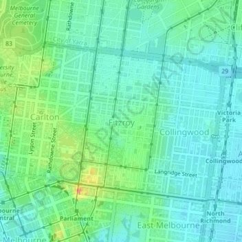
Name: Fitzroy topographic map, elevation, terrain.
Average elevation: 35 m
Minimum elevation: 18 m
Maximum elevation: 82 m
Fitzroy's topography is flat. It is laid out in grid plan and is characterised by a fairly tightly spaced rectangular grid of medium-sized streets, with many of its narrow streets and back lanes facilitating only one-way traffic. Its built form is a legacy of its early history when a mixture of land uses was allowed to develop close to each other, producing a great diversity of types and scales of building.
Other topographic maps
Click on a map to view its topography, its elevation and its terrain.
Renfew Court Reserve
Australia > Victoria > Melbourne
Renfew Court Reserve, Greenvale, Melbourne, City of Hume, Victoria, 3059, Australia
Average elevation: 131 m
Port Melbourne Beach
Australia > Victoria > Melbourne
Port Melbourne Beach, Beacon Cove, Port Melbourne, Melbourne, City of Port Phillip, Victoria, 3207, Australia
Average elevation: 3 m
Whittlesea
Australia > Victoria > Melbourne
Whittlesea, Melbourne, City of Whittlesea, Victoria, 3757, Australia
Average elevation: 363 m
Albert Park District
Australia > Victoria > Melbourne
Albert Park District, Melbourne, City of Port Phillip, Victoria, Australia
Average elevation: 10 m
Melbourne Water Reserve
Australia > Victoria > Melbourne
Melbourne Water Reserve, Ringwood North, Melbourne, City of Manningham, Victoria, Australia
Average elevation: 127 m
Mount Eliza
Australia > Victoria > Melbourne
Mount Eliza, Melbourne, Shire of Mornington Peninsula, Victoria, 3930, Australia
Average elevation: 60 m
Narre Warren North Retarding Basin (Melbourne Water)
Australia > Victoria > Melbourne
Narre Warren North Retarding Basin (Melbourne Water), Narre Warren North, Melbourne, City of Casey, Victoria, 3804, Australia
Average elevation: 76 m
Melbourne Water Pipe Reserve
Australia > Victoria > Melbourne
Melbourne Water Pipe Reserve, Burwood East, Melbourne, City of Whitehorse, Victoria, Australia
Average elevation: 118 m
Hampton Park
Australia > Victoria > Melbourne
Hampton Park, Melbourne, City of Casey, Victoria, 3976, Australia
Average elevation: 26 m
Abbotsford
Australia > Victoria > Melbourne
Abbotsford, Melbourne, City of Yarra, Victoria, 3067, Australia
Average elevation: 25 m
Tollkeepers Parade Reserve
Australia > Victoria > Melbourne
Tollkeepers Parade Reserve, Attwood, Melbourne, City of Hume, Victoria, Australia
Average elevation: 106 m
Eltham North
Australia > Victoria > Melbourne
Eltham North, Melbourne, Shire of Nillumbik, Victoria, Australia
Average elevation: 74 m
Malvern East
Australia > Victoria > Melbourne
Malvern East, Melbourne, City of Stonnington, Victoria, Australia
Average elevation: 47 m
Woori Yallock
Australia > Victoria > Melbourne > Woori Yallock
Woori Yallock, Melbourne, Shire of Yarra Ranges, Victoria, Australia
Average elevation: 145 m
Oakleigh South
Australia > Victoria > Melbourne
Oakleigh South, Melbourne, City of Monash, Victoria, Australia
Average elevation: 55 m
McMahons Creek
Australia > Victoria > Melbourne > McMahons Creek
McMahons Creek, Melbourne, Shire of Yarra Ranges, Victoria, Australia
Average elevation: 629 m
Tullamarine
Australia > Victoria > Melbourne
Tullamarine, Melbourne, City of Hume, Victoria, 3045, Australia
Average elevation: 90 m
Don Valley
Australia > Victoria > Melbourne
Don Valley, Melbourne, Shire of Yarra Ranges, Victoria, Australia
Average elevation: 388 m
Port Melbourne
Australia > Victoria > Melbourne
Port Melbourne, Melbourne, City of Port Phillip, Victoria, 3207, Australia
Average elevation: 4 m
Melbourne District
Australia > Victoria > Melbourne
Melbourne District, Melbourne, City of Melbourne, Victoria, Australia
Average elevation: 20 m
Donelly's Creek
Australia > Victoria > Melbourne
Donelly's Creek, Healesville, Melbourne, Shire of Yarra Ranges, Victoria, 3777, Australia
Average elevation: 143 m
Mornington District
Australia > Victoria > Melbourne
Mornington District, Melbourne, Shire of Mornington Peninsula, Victoria, Australia
Average elevation: 50 m