
Make a donation
Gear up for your next adventure:
As an Amazon Associate, this site earns from qualifying purchases at no extra cost to you.
Peters Canyon topographic map
Click on the map to display elevation.
Make a donation
Gear up for your next adventure:
As an Amazon Associate, this site earns from qualifying purchases at no extra cost to you.
About this map
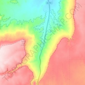
Name: Peters Canyon topographic map, elevation, terrain.
Location: Peters Canyon, San Juan County, Utah, United States (37.97976 -109.35691 38.05783 -109.34394)
Average elevation: 2,056 m
Minimum elevation: 1,833 m
Maximum elevation: 2,244 m
Make a donation
Gear up for your next adventure:
As an Amazon Associate, this site earns from qualifying purchases at no extra cost to you.
Other topographic maps
Click on a map to view its topography, its elevation and its terrain.
Salt Lake City
United States > Utah > Salt Lake County > Salt Lake City
Salt Lake City has an area of 110.4 square miles (286 km2) and an average elevation of 4,327 feet (1,319 m) above sea level. The lowest point within the boundaries of the city is 4,210 feet (1,280 m) near the Jordan River and the Great Salt Lake, and the highest is Grandview Peak, at 9,410 feet (2,868 m).
Average elevation: 1,625 m
San Juan River
The San Juan River begins in Archuleta County, Colorado at the confluence of its East and West Forks. Both forks originate above elevations of 10,000 feet (3,000 m) in the eastern San Juan Mountains in the San Juan National Forest. The river flows southwest through the foothills of the Rocky Mountains through…
Average elevation: 1,920 m
Make a donation
Gear up for your next adventure:
As an Amazon Associate, this site earns from qualifying purchases at no extra cost to you.
Ogden
United States > Utah > Weber County
According to the United States Census Bureau, the city has an area of 26.6 square miles (69 km2), all land. Elevations in the city range from about 4,300 to 5,000 feet (1,300 to 1,500 m) above sea level.
Average elevation: 1,498 m
Make a donation
Gear up for your next adventure:
As an Amazon Associate, this site earns from qualifying purchases at no extra cost to you.
Make a donation
Gear up for your next adventure:
As an Amazon Associate, this site earns from qualifying purchases at no extra cost to you.
Bluffdale
United States > Utah > Salt Lake County
Bluffdale has an area of 10.22 square miles (26.47 km2) and an average elevation of 4,436 feet (1,352 m) above sea level. Bluffdale is predominately located in Salt Lake County, though a portion of the city is in Utah County. Bluffdale shares city borders with Herriman to the west, Riverton to the north,…
Average elevation: 1,468 m
Arches National Park
United States > Utah > Grand County
The park consists of 310.31 km2 (76,680 acres; 119.81 sq mi; 31,031 ha) of high desert located on the Colorado Plateau. The highest elevation in the park is 5,653 ft (1,723 m) at Elephant Butte, and the lowest elevation is 4,085 ft (1,245 m) at the visitor center. The park receives an average of less than 10…
Average elevation: 1,476 m
Make a donation
Gear up for your next adventure:
As an Amazon Associate, this site earns from qualifying purchases at no extra cost to you.
Make a donation
Gear up for your next adventure:
As an Amazon Associate, this site earns from qualifying purchases at no extra cost to you.
Rich County
The southern half of Bear Lake and the Bear Lake Valley lies on the northern edge of the county. The Bear River Valley lies in most of the eastern portion of the county. The elevation of these valleys is close to 6,000 feet (1,800 m), and the rest of the county is covered by mountains, including the Bear River…
Average elevation: 2,148 m
Make a donation
Gear up for your next adventure:
As an Amazon Associate, this site earns from qualifying purchases at no extra cost to you.
Fish Lake
United States > Utah > Sevier County
Fish Lake is a high alpine lake (elevation approximately 8,848 ft or 2,700 m) located in the Fishlake/ Southern Wasatch Plateau region of south-central Utah, United States. It lies within and is the namesake of the Fishlake National Forest.
Average elevation: 2,886 m
Utah County
Utah Valley lies at the center of the county, lined by the mountains of the Wasatch Range on the east. Utah Lake occupies a large part of the valley. The elevation ranges from 4,487 feet (1,368 m) above sea level at the lake to 11,928 feet (3,636 m) at the peak of Mount Nebo.
Average elevation: 2,016 m
Make a donation
Gear up for your next adventure:
As an Amazon Associate, this site earns from qualifying purchases at no extra cost to you.
Bellwood Acres
United States > Utah > Salt Lake County > Cottonwood Heights
Average elevation: 1,398 m
American Fork
United States > Utah > Utah County
Elevations throughout the city range from 4,566 feet (1,392 m) to 4,619 feet (1,408 m) above sea level.
Average elevation: 1,405 m
Make a donation
Gear up for your next adventure:
As an Amazon Associate, this site earns from qualifying purchases at no extra cost to you.
Alta
United States > Utah > Salt Lake County
Alta experiences a high altitude humid continental climate (Köppen Dfb), which borders on a subalpine climate (Dfc), due to its high elevation. Due to its proximity to the Great Salt Lake, the town receives very heavy snows, averaging over 507 inches (12.9 m) per year. During the very wet season of 1982/1983,…
Average elevation: 2,912 m
Brighton
United States > Utah > Salt Lake County
Brighton has a high-altitude cold continental climate (Köppen Dsb/Dsc), with dry summers and very snowy winters.
Average elevation: 2,852 m
Make a donation
Gear up for your next adventure:
As an Amazon Associate, this site earns from qualifying purchases at no extra cost to you.
Ogden
United States > Utah > Weber County > Ogden
According to the United States Census Bureau, the city has an area of 26.6 square miles (69.0 km2), all land. Elevations in the city range from about 4,300 to 5,000 feet (1,300 to 1,500 m) above sea level.
Average elevation: 1,557 m
Make a donation
Gear up for your next adventure:
As an Amazon Associate, this site earns from qualifying purchases at no extra cost to you.
Logan
United States > Utah > Cache County > Logan
The city lies near the eastern edge of Cache Valley on the western slopes of the Bear River Mountains. Mount Logan rises to an elevation of 9,710 feet (2,960 m) immediately to the east, and south of Logan Canyon. The eastern portions of the city are constructed on top of shelf-like "benches", late Pleistocene…
Average elevation: 1,498 m
Make a donation
Gear up for your next adventure:
As an Amazon Associate, this site earns from qualifying purchases at no extra cost to you.
Brian Head
United States > Utah > Iron County
The community, at an elevation of 9,800 feet (3,000 m) above sea level, is the highest town in Utah. It is located on State Route 143 and is east of Interstate 15. Brian Head is approximately three miles north of Cedar Breaks National Monument.
Average elevation: 3,031 m
Make a donation
Gear up for your next adventure:
As an Amazon Associate, this site earns from qualifying purchases at no extra cost to you.
Park City
United States > Utah > Summit County > Park City
In the summertime, many valley residents of the Wasatch Front visit the town to escape high temperatures. Park City is usually cooler than Salt Lake City as it lies mostly higher than 7,000 feet (2,100 m) above sea level, while Salt Lake City is situated at an elevation of about 4,300 feet (1,300 m).
Average elevation: 2,315 m
Make a donation
Gear up for your next adventure:
As an Amazon Associate, this site earns from qualifying purchases at no extra cost to you.
Lake Powell
United States > Utah > Kane County
Concrete placement started around the clock on June 17, 1960. The last bucket of concrete was poured on September 13, 1963. Over 5 million cubic yards (4,000,000 m³) of concrete make up Glen Canyon Dam. The dam is 710 feet (216 m) high and the surface elevation of the water at full-pool is approximately 3700…
Average elevation: 1,555 m
Millard County
Pahvant Valley in Millard County has several ancient lava flows and extinct volcanoes, known as the Black Rock Desert volcanic field, including the "Black Rock" lava flow. About 17 miles (27 km) southwest of Delta, near Black Rock's northwest perimeter is a feature named the "Great Stone Face", which protrudes…
Average elevation: 1,726 m
Make a donation
Gear up for your next adventure:
As an Amazon Associate, this site earns from qualifying purchases at no extra cost to you.