
Alta topographic map
Click on the map to display elevation.
Alta
Alta experiences a high altitude humid continental climate (Köppen Dfb), which borders on a subalpine climate (Dfc), due to its high elevation. Due to its proximity to the Great Salt Lake, the town receives very heavy snows, averaging over 507 inches (12.9 m) per year. During the very wet season of 1982/1983, Alta received as much as 900 inches (23 m) of snow, leading to record flooding of Wasatch streams as the snow melted during May and June that year. Alta's total precipitation of 108.54 inches (2,756.9 mm) during 1983 is a record for a calendar year in any state of the Mountain West;.
About this map
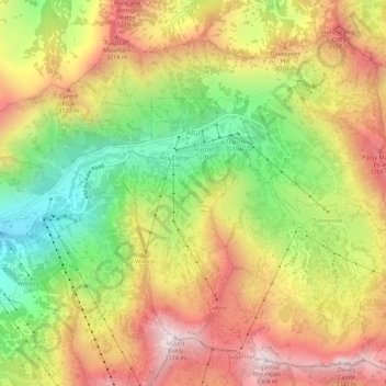
Name: Alta topographic map, elevation, terrain.
Location: Alta, Salt Lake County, Utah, United States (40.56441 -111.65273 40.60326 -111.59808)
Average elevation: 2,912 m
Minimum elevation: 2,437 m
Maximum elevation: 3,369 m
Other topographic maps
Click on a map to view its topography, its elevation and its terrain.
Salt Lake City
United States > Utah > Salt Lake County > Salt Lake City
Salt Lake City has an area of 110.4 square miles (286 km2) and an average elevation of 4,327 feet (1,319 m) above sea level. The lowest point within the boundaries of the city is 4,210 feet (1,280 m) near the Jordan River and the Great Salt Lake, and the highest is Grandview Peak, at 9,410 feet (2,868 m).
Average elevation: 1,625 m
Brighton
United States > Utah > Salt Lake County
Brighton has a high-altitude cold continental climate (Köppen Dsb/Dsc), with dry summers and very snowy winters.
Average elevation: 2,852 m
Bellwood Acres
United States > Utah > Salt Lake County > Cottonwood Heights
Average elevation: 1,398 m
South Valence Drainage
United States > Utah > Salt Lake County > West Jordan
Average elevation: 1,388 m