
Wildwood topographic map
Interactive map
Click on the map to display elevation.
About this map
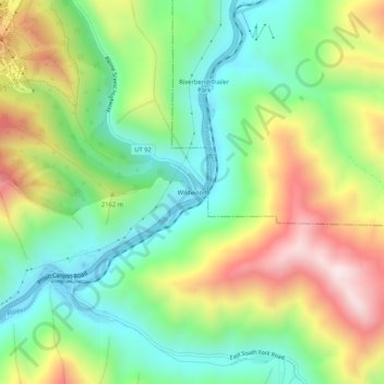
Name: Wildwood topographic map, elevation, terrain.
Location: Wildwood, Utah County, Utah, United States (40.34523 -111.57742 40.38523 -111.53742)
Average elevation: 1,879 m
Minimum elevation: 1,583 m
Maximum elevation: 2,347 m
Other topographic maps
Click on a map to view its topography, its elevation and its terrain.
American Fork
United States > Utah > Utah County
American Fork, Utah County, Utah, 84003, United States
Average elevation: 1,405 m
Provo
United States > Utah > Utah County > Provo
Provo, Utah County, Utah, 84606, United States
Average elevation: 1,733 m
Townsend
United States > Utah > Utah County > Genola > Townsend
Townsend, Genola, Utah County, Utah, United States
Average elevation: 1,438 m
Spanish Fork
United States > Utah > Utah County
Spanish Fork, Utah County, Utah, 84660, United States
Average elevation: 1,407 m
Provo
United States > Utah > Utah County
Provo, Utah County, Utah, United States
Average elevation: 1,728 m