
Uintah County topographic map
Interactive map
Click on the map to display elevation.
About this map
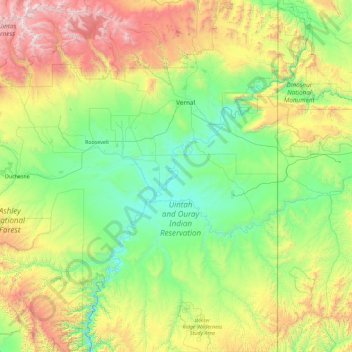
Name: Uintah County topographic map, elevation, terrain.
Location: Uintah County, Utah, United States (39.46171 -110.04785 40.85840 -109.04789)
Average elevation: 2,055 m
Minimum elevation: 1,394 m
Maximum elevation: 4,098 m
Uintah County lies on the east side of Utah. Its eastern border abuts the western border of the state of Colorado. The Green River flows southwestward through the central part of the county and forms the lower part of Uintah County's border with Duchesne County. Two miles south of Ouray, Utah, it is joined by the Duchesne River (flowing east-southeastward from Duchesne County), and three miles (5 km) farther down by the White River (flowing west-northwestward from Colorado). Ten miles farther downstream, it is joined by Willow Creek, flowing northward from the lower part of the county. The county terrain slopes to the south and to the west, with its highest parts found on the crests of the Uinta Mountains, running east-west across the northern border. The maximum elevation along those crests is around 12,276' (3742m). The county has a total area of 4,501 square miles (11,660 km2), of which 4,480 square miles (11,600 km2) is land and 22 square miles (57 km2) (0.5%) is water.
Other topographic maps
Click on a map to view its topography, its elevation and its terrain.
Saint George
United States > Utah > Washington County
Saint George, Washington County, Utah, United States
Average elevation: 929 m
Hatch
United States > Utah > Garfield County
Hatch, Garfield County, Utah, 84735, United States
Average elevation: 2,135 m
Draper Commercial Parkway
United States > Utah > Salt Lake County > Draper
Draper Commercial Parkway, Draper, Salt Lake County, Utah, 84020, United States
Average elevation: 1,355 m
Midlake
United States > Utah > Box Elder County
Midlake, Box Elder County, Utah, United States
Average elevation: 1,282 m
Zion National Park
United States > Utah > Washington County
Zion National Park, Washington County, Utah, United States
Average elevation: 1,877 m
Pinto Lake
United States > Utah > Duchesne County
Pinto Lake, Duchesne County, Utah, United States
Average elevation: 3,106 m
Gates Lake
United States > Utah > Duchesne County
Gates Lake, Duchesne County, Utah, United States
Average elevation: 3,121 m
Stettler
United States > Utah > Weber County > Ogden
Stettler, Ogden, Weber County, Utah, 84404, United States
Average elevation: 1,474 m
Park City
United States > Utah > Summit County
Park City, Summit County, Utah, United States
Average elevation: 2,290 m
Jeremy Ranch
United States > Utah > Summit County
Jeremy Ranch, Summit County, Utah, 84098, United States
Average elevation: 2,048 m
Magna
United States > Utah > Salt Lake County
Magna, Salt Lake County, Utah, United States
Average elevation: 1,341 m
Coal Creek
United States > Utah > Iron County > Cedar City
Coal Creek, Cedar City, Iron County, Utah, United States
Average elevation: 1,922 m
Bellwood Acres
United States > Utah > Salt Lake County > Cottonwood Heights
Bellwood Acres, Cottonwood Heights, Salt Lake County, Utah, 84121, United States
Average elevation: 1,398 m
Fish Lake
United States > Utah > Sevier County
Fish Lake, Sevier County, Utah, United States
Average elevation: 2,886 m
American Fork
United States > Utah > Utah County
American Fork, Utah County, Utah, 84003, United States
Average elevation: 1,405 m
Sprucewood
United States > Utah > Salt Lake County > Sandy
Sprucewood, Sandy, Salt Lake County, Utah, 84094, United States
Average elevation: 1,418 m
West Valley City
United States > Utah > Salt Lake County
West Valley City, Salt Lake County, Utah, United States
Average elevation: 1,351 m
New Harmony
United States > Utah > Washington County
New Harmony, Washington County, Utah, United States
Average elevation: 1,636 m
Wildwood
United States > Utah > Utah County
Wildwood, Utah County, Utah, United States
Average elevation: 1,879 m
Alta
United States > Utah > Salt Lake County
Alta, Salt Lake County, Utah, United States
Average elevation: 2,912 m
Brighton
United States > Utah > Salt Lake County
Brighton, Salt Lake County, Utah, United States
Average elevation: 2,852 m
West Jordan
United States > Utah > Salt Lake County
West Jordan, Salt Lake County, Utah, United States
Average elevation: 1,372 m
Alta Vista
United States > Utah > Weber County > Ogden
Alta Vista, Ogden, Weber County, Utah, United States
Average elevation: 1,505 m
Midvale
United States > Utah > Salt Lake County
Midvale, Salt Lake County, Utah, 84047, United States
Average elevation: 1,331 m
Woods Cross
United States > Utah > Davis County
Woods Cross, Davis County, Utah, 84087, United States
Average elevation: 1,352 m
Midway
United States > Utah > Wasatch County
Midway, Wasatch County, Utah, 84049, United States
Average elevation: 1,751 m
Salt Lake City
United States > Utah > Salt Lake County
Salt Lake City, Salt Lake County, Utah, United States
Average elevation: 1,592 m
Salt Lake City
United States > Utah > Salt Lake County > Salt Lake City
Salt Lake City, Salt Lake County, Utah, 84139, United States
Average elevation: 1,625 m
Three Canyon Rapids
United States > Utah > Carbon County
Three Canyon Rapids, Carbon County, Utah, United States
Average elevation: 1,511 m
Sandy
United States > Utah > Salt Lake County
Sandy, Salt Lake County, Utah, United States
Average elevation: 1,376 m
Moab
United States > Utah > Grand County
Moab, Grand County, Utah, 84532, United States
Average elevation: 1,357 m
Hillborough Heights
United States > Utah > Salt Lake County > Sandy > Hillborough Heights
Hillborough Heights, Sandy, Salt Lake County, Utah, 84093, United States
Average elevation: 1,501 m
South Valence Drainage
United States > Utah > Salt Lake County > West Jordan
South Valence Drainage, West Jordan, Salt Lake County, Utah, United States
Average elevation: 1,388 m
Lake Powell
United States > Utah > Kane County
Lake Powell, Kane County, Utah, United States
Average elevation: 1,555 m
Millcreek
United States > Utah > Salt Lake County > Millcreek
Millcreek, Salt Lake County, Utah, 84106, United States
Average elevation: 1,715 m
Cannonville
United States > Utah > Garfield County > Cannonville
Cannonville, Garfield County, Utah, 84718, United States
Average elevation: 1,894 m
South Jordan
United States > Utah > Salt Lake County > South Jordan
South Jordan, Salt Lake County, Utah, United States
Average elevation: 1,384 m
Riverton
United States > Utah > Riverton > Riverton
Riverton, Salt Lake County, Utah, 84065, United States
Average elevation: 1,376 m
Wildcat Hills
United States > Utah > Box Elder County
Wildcat Hills, Box Elder County, Utah, United States
Average elevation: 1,464 m
Park City
United States > Utah > Summit County > Park City
Park City, Summit County, Utah, 84060, United States
Average elevation: 2,315 m
Peter Sinks
Peter Sinks, Cache County, Utah, United States
Average elevation: 2,555 m
Cedar City
United States > Utah > Iron County
Cedar City, Iron County, Utah, United States
Average elevation: 1,975 m
Provo
United States > Utah > Utah County > Provo
Provo, Utah County, Utah, 84606, United States
Average elevation: 1,733 m
Huntsville
United States > Utah > Huntsville
Huntsville, Weber County, Utah, United States
Average elevation: 1,502 m