
Shanxi topographic map
Interactive map
Click on the map to display elevation.
About this map
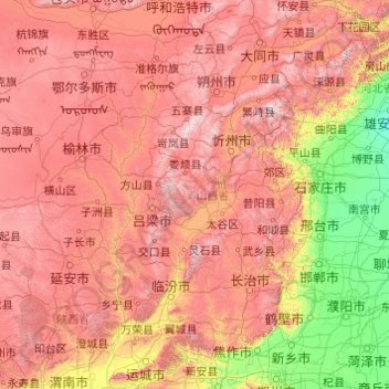
Name: Shanxi topographic map, elevation, terrain.
Location: Shanxi, China (34.58407 110.21954 40.74496 114.56551)
Average elevation: 936 m
Minimum elevation: 7 m
Maximum elevation: 2,872 m
Shanxi is located on a plateau made up of higher ground to the east (Taihang Mountains) and the west (Lüliang Mountains) and a series of valleys in the center through which the Fen River runs. The highest peak is Mount Wutai (Wutai Shan) in northeastern Shanxi with an altitude of 3,058 m. The Great Wall of China forms most of the northern border with Inner Mongolia. The Zhongtiao Mountains run along part of the southern border and separate Shanxi from the east–west part of the Yellow River. Mount Hua is to the southwest.
Other topographic maps
Click on a map to view its topography, its elevation and its terrain.
Nam Bin Wai
China > Hong Kong > Yuen Long District > Tai Kiu Village
Nam Bin Wai, Tai Kiu Village, Yuen Long District, New Territories, Hong Kong, China
Average elevation: 16 m
CN/VN disputes in Paracel Islands
CN/VN disputes in Paracel Islands, Hainan Province, 573199, China
Average elevation: 0 m
Lion mountain
China > Zhejiang > Hangzhou City
Lion mountain, Hangzhou City, Zhejiang, 310024, China
Average elevation: 15 m
Tazhong
China > Xinjiang > Qarqan County > Tazhong Town
Tazhong, Tazhong Town, Qarqan County, Bayingolin, Xinjiang, China
Average elevation: 1,116 m
Keriya County
Keriya County, Hotan Prefecture, Xinjiang, 848400, China
Average elevation: 2,410 m
Yau Oi Chuen
China > Hong Kong > Sha Tin District > Tung Lo Wan
Yau Oi Chuen, Tung Lo Wan, Sha Tin District, New Territories, Hong Kong, China
Average elevation: 156 m
Wuhua District
Wuhua District, Kunming, Yunnan, China
Average elevation: 2,104 m
Daxingnanjiecun
China > Henan > Tangyin County
Daxingnanjiecun, Tangyin County, Anyang, Henan, China
Average elevation: 85 m
Ap Lei Chau
China > Hong Kong > Hong Kong Island
Ap Lei Chau, Southern District, Hong Kong Island, Hong Kong, China
Average elevation: 25 m
Yaha
China > Gansu > Zhugqu County > Wuping
Yaha, Wuping, Zhugqu County, Gannan, Gansu, 746300, China
Average elevation: 2,174 m
Huancui District
Huancui District, Weihai, Shandong, 264200, China
Average elevation: 41 m
Tai Mo Shan
China > Hong Kong > Tsuen Wan District
Tai Mo Shan, Tsuen Wan District, New Territories, Hong Kong, China
Average elevation: 600 m
Yiwu County
Yiwu County, Hami, Yiwu, Xinjiang, China
Average elevation: 1,215 m
Kaba
China > Xinjiang > Habahe County > 阿克齐镇
Kaba, 阿克齐镇, Habahe County, Altay Prefecture, Xinjiang, China
Average elevation: 557 m