Geolocate

Qiannan topographic map

Click on the map to display elevation.

About this map

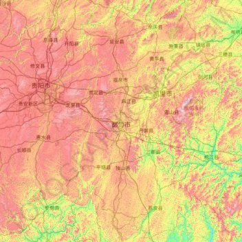
Name: Qiannan topographic map, elevation, terrain.

Location: Qiannan, Guizhou, 558000, China (25.07962 106.20748 27.48483 108.30204)

Average elevation: 945 m

Minimum elevation: 228 m

Maximum elevation: 2,127 m

Other topographic maps

Click on a map to view its topography, its elevation and its terrain.

Keji

China > Guizhou > Anlong > Sayu

Average elevation: 1,437 m

Napan

China > Guizhou > Wangmo

Average elevation: 1,078 m

Gear up for your next adventure:

🛶Canoe Life Vest - Safety vest for water sports
🧦Hiking Socks - Moisture-wicking and comfortable socks for long hikes
💡Solar Camping Lamp - Eco-friendly lighting for campsites
👟Trail Running Shoes - Agile footwear for fast-paced topographic exploration
🏃Hydration Running Vest - Carry water and maps close to your body for speed

As an Amazon Associate, this site earns from qualifying purchases at no extra cost to you.