
Make a donation
Gear up for your next adventure:
As an Amazon Associate, this site earns from qualifying purchases at no extra cost to you.
Huancui District topographic map
Click on the map to display elevation.
Make a donation
Gear up for your next adventure:
As an Amazon Associate, this site earns from qualifying purchases at no extra cost to you.
Huancui District
Huancui District is relatively low in elevation, with only a few peaks rising above 500 metres (1,600 ft) in height. The district's southern edge lies along the eastern portion of the Jiaolai Plains [zh].
Make a donation
Gear up for your next adventure:
As an Amazon Associate, this site earns from qualifying purchases at no extra cost to you.
About this map
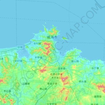
Name: Huancui District topographic map, elevation, terrain.
Location: Huancui District, Weihai, Shandong, 264200, China (37.21403 121.85852 37.67186 122.40477)
Average elevation: 41 m
Minimum elevation: -2 m
Maximum elevation: 471 m
Make a donation
Gear up for your next adventure:
As an Amazon Associate, this site earns from qualifying purchases at no extra cost to you.
Other topographic maps
Click on a map to view its topography, its elevation and its terrain.
Make a donation
Gear up for your next adventure:
As an Amazon Associate, this site earns from qualifying purchases at no extra cost to you.