Geolocate

Ningbo topographic map

Click on the map to display elevation.

About this map

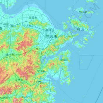
Name: Ningbo topographic map, elevation, terrain.

Location: Ningbo, Zhejiang, China (28.75609 120.89128 30.45445 122.61609)

Average elevation: 92 m

Minimum elevation: -3 m

Maximum elevation: 1,319 m

Other topographic maps

Click on a map to view its topography, its elevation and its terrain.

Lion mountain

China > Zhejiang > Hangzhou City

Average elevation: 15 m

甘山

China > Zhejiang > Chun'an County

Average elevation: 250 m

Chian

China > Zhejiang

Average elevation: 130 m

Gear up for your next adventure:

🔪Outdoor Multitool - Versatile tool for repairs and food prep in the wild
🛁Quick-Dry Microfiber Towel - Space-saving towel that dries rapidly on the move
👟Trail Running Shoes - Agile footwear for fast-paced topographic exploration
🔦LED Flashlight - Powerful and long-lasting flashlight for camping and emergencies
💧Collapsible Water Bottle - Space-saving water bottle for outdoor activities

As an Amazon Associate, this site earns from qualifying purchases at no extra cost to you.