Geolocate

Chengde topographic map

Click on the map to display elevation.

About this map

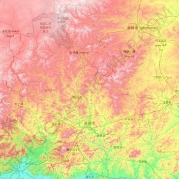
Name: Chengde topographic map, elevation, terrain.

Location: Chengde, Hebei, 067000, China (40.19007 115.90387 42.61764 119.24330)

Average elevation: 828 m

Minimum elevation: 27 m

Maximum elevation: 1,993 m

Other topographic maps

Click on a map to view its topography, its elevation and its terrain.

Zhangbei

China > Hebei > Zhangbei

Average elevation: 1,439 m

Gear up for your next adventure:

🔭Outdoor Binoculars - Lightweight binoculars for birdwatching and hiking
🩹Compact First Aid Kit - Pre-packed essentials for common trail injuries
💡LED Headlamp - Hands-free illumination for night hiking and camping
🎒Backpack Rain Cover - External shield to keep your entire pack dry
🧤Thermal Hiking Gloves - Grip-enhanced gloves for cold-weather altitude trekking

As an Amazon Associate, this site earns from qualifying purchases at no extra cost to you.