
Lloró topographic map
Click on the map to display elevation.
About this map
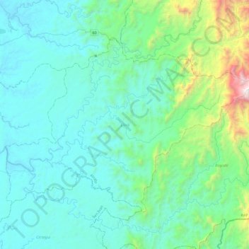
Name: Lloró topographic map, elevation, terrain.
Location: Lloró, Atrato, Chocó, RAP Pacífico, Colombia (5.42751 -76.59040 5.74158 -76.13936)
Average elevation: 407 m
Minimum elevation: 25 m
Maximum elevation: 2,743 m
Other topographic maps
Click on a map to view its topography, its elevation and its terrain.
Quibdó
Colombia > Chocó > Quibdó > Quibdó
Quibdó se encuentra situado sobre la margen derecha del río Atrato, uno de los principales afluentes del país y una de las zonas con más alta pluviosidad del mundo. Se encuentra a una altitud de 43 m s. n. m. y tiene una temperatura cuyo promedio es de 28 ℃. Dista de Bogotá 557 kilómetros (346 mi).
Average elevation: 57 m
Bagadó
Bagadó es un municipio colombiano ubicado en el departamento de Chocó. Se encuentra a una altitud de 200 m s. n. m. y a 80 km de la capital del departamento, Quibdó. Fue fundado en 1578, y convertido en municipio en 1909. La temperatura promedio es de 28 °C. En el municipio se encuentra el resguardo…
Average elevation: 131 m
Managrú
Colombia > Chocó > El Cantón de San Pablo
El municipio El Cantón del San Pablo tiene una extensión territorial total de 386 km². Se encuentra a una altitud de 57 m s. n. m., y tiene una temperatura promedio de 28 °C.
Average elevation: 54 m
Santa Genoveva de Docordó
Colombia > Chocó > El Litoral del San Juan
Su extensión territorial es de 3.755 km² y cuenta con una temperatura promedio de 28 °C. Se encuentra a una altitud de 25 m s. n. m. Cuenta con una población de 850 habitantes en el sector urbano y 5.891 habitantes en el sector rural. Sus tierras se distribuyen en los pisos térmicos cálido, templado y frío.
Average elevation: 7 m
Pie de Pató
Colombia > Chocó > Alto Baudó (Pie de Pató)
Alto Baudó es un municipio de Colombia ubicado en el departamento de Chocó. Situado en el valle del río Baudó, su cabecera municipal es Pie de Pató. Se encuentra a una altitud de 50 m s. n. m. y a 80 km al sur de la capital del departamento, Quibdó. La extensión del municipio es de 1.532 km².
Average elevation: 97 m
Bagadó
Bagadó es un municipio colombiano ubicado en el departamento de Chocó. Se encuentra a una altitud de 200 m s. n. m. y a 80 km de la capital del departamento, Quibdó. Fue fundado en 1578, y convertido en municipio en 1909. La temperatura promedio es de 28 °C. En el municipio se encuentra el resguardo…
Average elevation: 131 m