Geolocate

Andagoya topographic map

Click on the map to display elevation.

About this map

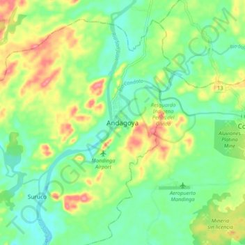
Name: Andagoya topographic map, elevation, terrain.

Location: Andagoya, Medio San Juan, San Juan, Chocó, RAP Pacífico, Colombia (5.05327 -76.73367 5.13327 -76.65367)

Average elevation: 56 m

Minimum elevation: 23 m

Maximum elevation: 111 m

Other topographic maps

Click on a map to view its topography, its elevation and its terrain.

Gear up for your next adventure:

🛰️Satellite Messenger - Emergency communication for areas with no cell service
🥾Hiking Leggings - Comfortable leggings for outdoor activities
🛌Insulated Sleeping Pad - Critical thermal barrier between you and the cold ground
🧭GPS Tracker - Track your location in remote areas safely
🕯️Camping Lantern - Illuminates your entire campsite with high-efficiency LEDs

As an Amazon Associate, this site earns from qualifying purchases at no extra cost to you.