
Make a donation
Gear up for your next adventure:
As an Amazon Associate, this site earns from qualifying purchases at no extra cost to you.
Pie de Pató topographic map
Click on the map to display elevation.
Make a donation
Gear up for your next adventure:
As an Amazon Associate, this site earns from qualifying purchases at no extra cost to you.
Pie de Pató
Alto Baudó es un municipio de Colombia ubicado en el departamento de Chocó. Situado en el valle del río Baudó, su cabecera municipal es Pie de Pató. Se encuentra a una altitud de 50 m s. n. m. y a 80 km al sur de la capital del departamento, Quibdó. La extensión del municipio es de 1.532 km².
Make a donation
Gear up for your next adventure:
As an Amazon Associate, this site earns from qualifying purchases at no extra cost to you.
About this map
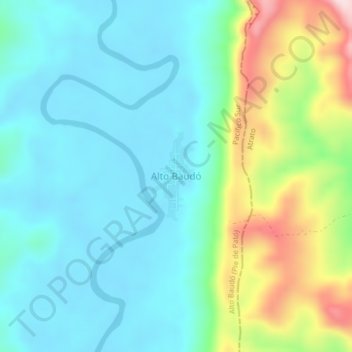
Name: Pie de Pató topographic map, elevation, terrain.
Average elevation: 97 m
Minimum elevation: 6 m
Maximum elevation: 364 m
Make a donation
Gear up for your next adventure:
As an Amazon Associate, this site earns from qualifying purchases at no extra cost to you.
Other topographic maps
Click on a map to view its topography, its elevation and its terrain.