
Centro topographic map
Click on the map to display elevation.
Centro
La topografía de Montería es básicamente plana, con algunas elevaciones de menor importancia. La parte occidental de la ciudad está surcada por la serranía de Las Palomas. Al norte limita con el municipio de Cereté, Puerto Escondido y San Pelayo; al este con San Carlos y Planeta Rica; al sur con Tierralta y Valencia; al oeste con el departamento de Antioquia y los municipios de Canalete, Puerto Escondido y Los Córdobas.
About this map
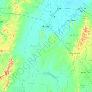
Name: Centro topographic map, elevation, terrain.
Location: Centro, Córdoba, RAP Caribe, Colombia (8.26308 -76.27881 8.94632 -75.66941)
Average elevation: 66 m
Minimum elevation: 4 m
Maximum elevation: 441 m
Other topographic maps
Click on a map to view its topography, its elevation and its terrain.
San Carlos
Colombia > Córdoba > San Carlos
Ubicado en la zona urbana del municipio, presenta una altitud promedio de 150 m s. n. m. Es el cerro símbolo del pueblo, en él se logran ver algunos pueblos a la distancia como Montería, Cereté, Ciénaga de Oro entre otros, además de los excelentes paisajes que logran apreciarse desde su cima.
Average elevation: 21 m
Montería
La topografía de Montería es básicamente plana, con algunas elevaciones de menor importancia. La parte occidental de la ciudad está surcada por la serranía de Las Palomas. Al norte limita con el municipio de Cereté, Puerto Escondido y San Pelayo; al este con San Carlos y Planeta Rica; al sur con…
Average elevation: 25 m
Ciénaga de Oro
Colombia > Córdoba > Ciénaga de Oro
Se dice que desde la Edad Secundaria de la tierra, apareció la Cordillera Occidental que atraviesa a Colombia de sur a norte, y de la cual se desprenden las serranías de Abibe, San Jerónimo y Ayapel que entran al departamento de Córdoba. De las tres serranías, la de San Jerónimo penetra a Ciénaga de…
Average elevation: 21 m
Playas de San Bernardo del Viento
Colombia > Córdoba > San Bernardo del Viento > Paso Nuevo > Miramar
Average elevation: 8 m
La Apartada
Colombia > Córdoba > La Apartada
El territorio presenta una topografía poco accidentada, con una altitud promedio de 60 m s. n. m. y con ligeras ondulaciones que no sobrepasan los 200 m s. n. m.
Average elevation: 39 m
Planeta Rica
Colombia > Córdoba > Planeta Rica
Por no tener fecha clara de fundación se acordó por consenso tomar como fecha de fundación el 10 de febrero de 1885; en ese año unos doscientos metros más al sur formaron una plazoleta triangular que se llamó "Plaza de San Roque". Este fue en su momento el punto geográfico más alto y apto para lograr…
Average elevation: 77 m
San Carlos
Colombia > Córdoba > San Carlos
Ubicado en la zona urbana del municipio, presenta una altitud promedio de 150 m s. n. m. Es el cerro símbolo del pueblo, en él se logran ver algunos pueblos a la distancia como Montería, Cereté, Ciénaga de Oro entre otros, además de los excelentes paisajes que logran apreciarse desde su cima.
Average elevation: 21 m