Geolocate

Valencia topographic map

Click on the map to display elevation.

About this map

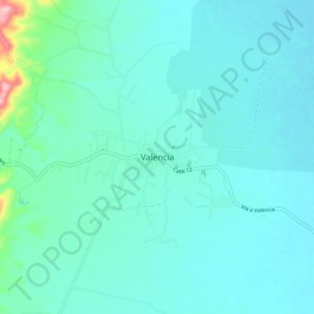
Name: Valencia topographic map, elevation, terrain.

Location: Valencia, Alto Sinú, Córdoba, RAP Caribe, Colombia (8.21909 -76.18812 8.29909 -76.10812)

Average elevation: 60 m

Minimum elevation: 36 m

Maximum elevation: 224 m

Gear up for your next adventure:

🥾Waterproof Hiking Boots - Essential footwear for rugged terrain and wet Canadian trails
🪑Ultralight Camping Stool - Compact seating for rest stops during long hikes
Family Camping Tent - Spacious tent suitable for family camping trips
🚲Handlebar Phone Mount - View topographic-map.com live while cycling
Camping Groundsheet - Protect your tent from moisture and dirt

As an Amazon Associate, this site earns from qualifying purchases at no extra cost to you.