Geolocate

Chinú topographic map

Click on the map to display elevation.

About this map

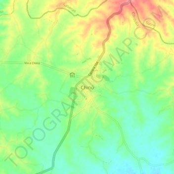
Name: Chinú topographic map, elevation, terrain.

Location: Chinú, Sabanas, Córdoba, Colombia (9.06636 -75.43890 9.14636 -75.35890)

Average elevation: 106 m

Minimum elevation: 73 m

Maximum elevation: 161 m

Gear up for your next adventure:

🧴Outdoor Sunscreen - High SPF protection for high-altitude UV exposure
🔋Solar Power Bank - Keep your GPS and devices charged during long outdoor trips
🥾Hiking Shorts - Breathable shorts suitable for summer hikes
🥾Lightweight Hiking Shoes - Comfortable shoes for day hikes
🥾Trail Hiking Boots - Supportive boots for rough trails

As an Amazon Associate, this site earns from qualifying purchases at no extra cost to you.