Geolocate

Amanora topographic map

Click on the map to display elevation.

About this map

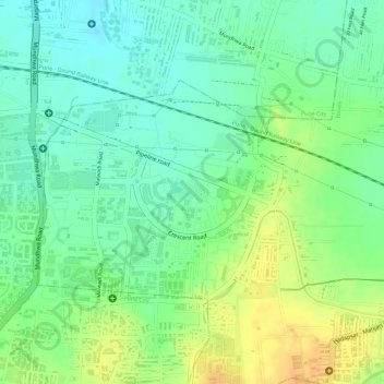
Name: Amanora topographic map, elevation, terrain.

Location: Amanora, Haveli, Pune, Maharashtra, India (18.51685 73.94233 18.51869 73.94502)

Average elevation: 560 m

Minimum elevation: 544 m

Maximum elevation: 578 m

Other topographic maps

Click on a map to view its topography, its elevation and its terrain.

Sinhagad

India > Maharashtra > Haveli

Average elevation: 994 m

Dhayari

India > Maharashtra > Haveli

Average elevation: 676 m

Khed Shivapur

India > Maharashtra > Haveli

Average elevation: 770 m

Mutha

India > Maharashtra > Haveli > Sangrun

Average elevation: 671 m

Wadki

India > Maharashtra > Haveli

Average elevation: 665 m

Uruli Kanchan

India > Maharashtra > Haveli

Average elevation: 558 m

Loni Kalbhor

India > Maharashtra > Haveli

Average elevation: 546 m

Khadakwasla

India > Maharashtra > Haveli

Average elevation: 601 m

Pimpri-Chinchwad

India > Maharashtra > Haveli

Pimpri-Chinchwad also known as "PCMC", is a city in the Indian state of Maharashtra. The city is about 15 km (9.3 mi) northwest of the historic city of Pune, at an altitude of 590 m (1,940 ft) above sea level. It is the fifth largest city in Maharashtra and the nineteenth largest city in India and the…

Average elevation: 605 m

Malkhed

India > Maharashtra > Haveli

Average elevation: 630 m

Ravet

India > Maharashtra > Haveli

Average elevation: 576 m

Khadakwasla

India > Maharashtra > Haveli

Average elevation: 601 m

Fursungi

India > Maharashtra > Haveli

Average elevation: 573 m

Gorhe

India > Maharashtra > Haveli

Average elevation: 610 m

Wadebolai

India > Maharashtra > Haveli

Average elevation: 586 m

Mamurdi

India > Maharashtra > Haveli

Average elevation: 606 m

Jambhali

India > Maharashtra > Haveli

Average elevation: 659 m

Gorhe

India > Maharashtra > Haveli

Average elevation: 610 m

Bhilarwadi

India > Maharashtra > Haveli > Peth

Average elevation: 976 m

Fursungi

India > Maharashtra > Haveli

Average elevation: 573 m

Theur

India > Maharashtra > Haveli

Average elevation: 539 m

Ashtapur

India > Maharashtra > Haveli

Average elevation: 541 m

Nanded City Eco Park

India > Maharashtra > Haveli > Pune

Average elevation: 576 m

Manter Wadi

India > Maharashtra > Haveli

Average elevation: 591 m

Vaswewadi

India > Maharashtra > Haveli > Vaswewadi

Average elevation: 682 m

Sonapur

India > Maharashtra > Haveli > Sonapur

Average elevation: 641 m

Pimpri-Chinchwad

India > Maharashtra > Haveli

Pimpri-Chinchwad also known as "PCMC", is a city in the Indian state of Maharashtra. The city is about 15 km (9.3 mi) northwest of the historic city of Pune, at an altitude of 590 m (1,940 ft) above sea level. It is the fifth largest city in Maharashtra and the nineteenth largest city in India and the…

Average elevation: 605 m

Gear up for your next adventure:

Lightweight Backpacking Tent - Compact tent for efficient hiking trips
🔦LED Headtorch - Bright and durable light for night activities
🚲Handlebar Phone Mount - View topographic-map.com live while cycling
🧼Travel Hand Sanitizer - Keep hands clean when water is scarce
🔦UV Flashlight - Detect minerals or specific insects in the dark

As an Amazon Associate, this site earns from qualifying purchases at no extra cost to you.