Geolocate

Gorhe topographic map

Click on the map to display elevation.

About this map

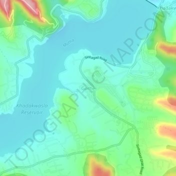
Name: Gorhe topographic map, elevation, terrain.

Location: Gorhe, Haveli, Pune District, Maharashtra, 411025, India (18.40095 73.73579 18.44095 73.77579)

Average elevation: 610 m

Minimum elevation: 566 m

Maximum elevation: 765 m

Other topographic maps

Click on a map to view its topography, its elevation and its terrain.

Sentosa Water Park

India > Maharashtra > Haveli > Ravet

Average elevation: 577 m

Mutha

India > Maharashtra > Haveli > Sangrun

Average elevation: 671 m

Sinhagad Fort

India > Maharashtra > Haveli > Kalyan Gaon

Average elevation: 995 m

Moshi Traffic Park

India > Maharashtra > Haveli

Average elevation: 603 m

Indrayani river

India > Maharashtra > Haveli > Pimpri-Chinchwad

Average elevation: 584 m

Amanora

India > Maharashtra > Haveli

Average elevation: 560 m

Moshi Traffic Park

India > Maharashtra > Haveli

Average elevation: 603 m

Khadakwasla Dam

India > Maharashtra > Haveli > Khadakwasla

Average elevation: 589 m

Ganesh Talav

India > Maharashtra > Haveli > Pimpri-Chinchwad

Average elevation: 593 m

Bird Valley Lake

India > Maharashtra > Haveli > Pimpri-Chinchwad

Average elevation: 594 m

Gear up for your next adventure:

🧴Waterproofing Spray - Restore the DWR coating on jackets and tents
🧥Waterproof Hiking Jacket - Protect yourself from rain and wind while hiking
🧦Outdoor Socks - Durable socks designed for hiking and outdoor sports
🛌Insulated Sleeping Pad - Critical thermal barrier between you and the cold ground
🧦Hiking Liner Socks - Thin base layer to prevent friction and blisters

As an Amazon Associate, this site earns from qualifying purchases at no extra cost to you.