Geolocate

Theur topographic map

Click on the map to display elevation.

About this map

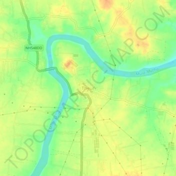
Name: Theur topographic map, elevation, terrain.

Location: Theur, Haveli, Pune District, Maharashtra, 412201, India (18.50432 74.02648 18.54432 74.06648)

Average elevation: 539 m

Minimum elevation: 519 m

Maximum elevation: 554 m

Other topographic maps

Click on a map to view its topography, its elevation and its terrain.

Khadakwasla Dam

India > Maharashtra > Haveli > Khadakwasla

Average elevation: 589 m

Ganesh Talav

India > Maharashtra > Haveli > Pimpri-Chinchwad

Average elevation: 593 m

Indrayani river

India > Maharashtra > Haveli > Pimpri-Chinchwad

Average elevation: 584 m

Amanora

India > Maharashtra > Haveli

Average elevation: 560 m

Sentosa Water Park

India > Maharashtra > Haveli > Ravet

Average elevation: 577 m

Bird Valley Lake

India > Maharashtra > Haveli > Pimpri-Chinchwad

Average elevation: 594 m

Mutha

India > Maharashtra > Haveli > Sangrun

Average elevation: 671 m

Moshi Traffic Park

India > Maharashtra > Haveli

Average elevation: 603 m

Sinhagad Fort

India > Maharashtra > Haveli > Kalyan Gaon

Average elevation: 995 m

Moshi Traffic Park

India > Maharashtra > Haveli

Average elevation: 603 m

Gear up for your next adventure:

Family Camping Tent - Spacious tent suitable for family camping trips
🦟Insect Repellent - Keep mosquitoes and black flies away in wooded areas
💧Filtered Water Bottle - Safe drinking water on the go
🧦Merino Wool Socks - Moisture-wicking comfort for long-distance hiking
👖Convertible Hiking Pants - Zip-off legs to adapt to changing weather conditions

As an Amazon Associate, this site earns from qualifying purchases at no extra cost to you.