Geolocate

Sonapur topographic map

Click on the map to display elevation.

About this map

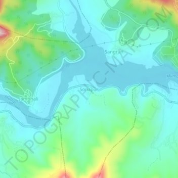
Name: Sonapur topographic map, elevation, terrain.

Location: Sonapur, Haveli, Pune District, Maharashtra, India (18.37114 73.65087 18.41114 73.69087)

Average elevation: 641 m

Minimum elevation: 572 m

Maximum elevation: 903 m

Gear up for your next adventure:

🕯️Camping Lantern - Illuminates your entire campsite with high-efficiency LEDs
💧Hydration Pack - Hands-free hydration system for long hikes
🗺️Topographic Maps - Detailed maps to explore trails, mountains, and wilderness areas
🧥Insulated Jacket - Keep warm in cold outdoor conditions
🚲Bike Repair Kit - Essential tools for on-trail mechanical issues

As an Amazon Associate, this site earns from qualifying purchases at no extra cost to you.