Geolocate

Jambhali topographic map

Click on the map to display elevation.

About this map

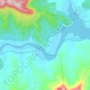
Name: Jambhali topographic map, elevation, terrain.

Location: Jambhali, Haveli, Maharashtra, India (18.36907 73.63656 18.40907 73.67656)

Average elevation: 659 m

Minimum elevation: 577 m

Maximum elevation: 982 m

Other topographic maps

Click on a map to view its topography, its elevation and its terrain.

Sentosa Water Park

India > Maharashtra > Haveli > Ravet

Average elevation: 577 m

Mutha

India > Maharashtra > Haveli > Sangrun

Average elevation: 671 m

Sinhagad Fort

India > Maharashtra > Haveli > Kalyan Gaon

Average elevation: 995 m

Moshi Traffic Park

India > Maharashtra > Haveli

Average elevation: 603 m

Indrayani river

India > Maharashtra > Haveli > Pimpri-Chinchwad

Average elevation: 584 m

Amanora

India > Maharashtra > Haveli

Average elevation: 560 m

Moshi Traffic Park

India > Maharashtra > Haveli

Average elevation: 603 m

Khadakwasla Dam

India > Maharashtra > Haveli > Khadakwasla

Average elevation: 589 m

Ganesh Talav

India > Maharashtra > Haveli > Pimpri-Chinchwad

Average elevation: 593 m

Bird Valley Lake

India > Maharashtra > Haveli > Pimpri-Chinchwad

Average elevation: 594 m

Gear up for your next adventure:

🧢Sun Hat - Wide-brim hat for sun protection
🔋Solar Power Bank - Keep your GPS and devices charged during long outdoor trips
🧼Biodegradable Camp Soap - Environmentally friendly cleaning for gear and body
🔭Compact Monocular - One-handed bird watching and trail spotting
🥤Collapsible Travel Cup - Saves space and weight in your mess kit

As an Amazon Associate, this site earns from qualifying purchases at no extra cost to you.