Geolocate

Malkhed topographic map

Click on the map to display elevation.

About this map

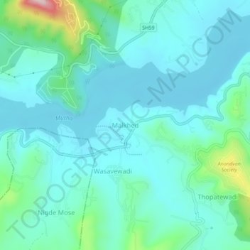
Name: Malkhed topographic map, elevation, terrain.

Location: Malkhed, Haveli, Pune District, Maharashtra, 411025, India (18.37296 73.68105 18.41296 73.72105)

Average elevation: 630 m

Minimum elevation: 571 m

Maximum elevation: 919 m

Other topographic maps

Click on a map to view its topography, its elevation and its terrain.

Indrayani river

India > Maharashtra > Haveli > Pimpri-Chinchwad

Average elevation: 584 m

Khadakwasla Dam

India > Maharashtra > Haveli > Khadakwasla

Average elevation: 589 m

Ganesh Talav

India > Maharashtra > Haveli > Pimpri-Chinchwad

Average elevation: 593 m

Amanora

India > Maharashtra > Haveli

Average elevation: 560 m

Sentosa Water Park

India > Maharashtra > Haveli > Ravet

Average elevation: 577 m

Bird Valley Lake

India > Maharashtra > Haveli > Pimpri-Chinchwad

Average elevation: 594 m

Moshi Traffic Park

India > Maharashtra > Haveli

Average elevation: 603 m

Mutha

India > Maharashtra > Haveli > Sangrun

Average elevation: 671 m

Sinhagad Fort

India > Maharashtra > Haveli > Kalyan Gaon

Average elevation: 995 m

Moshi Traffic Park

India > Maharashtra > Haveli

Average elevation: 603 m

Gear up for your next adventure:

💧Hydration Bladder - Hands-free hydration solution for long treks
🧢Beanie Hat - Keep your head warm in cold weather
🧴Sunscreen SPF - Broad-spectrum sunscreen for outdoor activities
💡LED Camping Lantern - Illuminate your campsite with long-lasting lanterns
👟Trail Running Shoes - Agile footwear for fast-paced topographic exploration

As an Amazon Associate, this site earns from qualifying purchases at no extra cost to you.