Geolocate

Punjab topographic map

Interactive map

Click on the map to display elevation.

Punjab topographic map, elevation, terrain

Punjab topographic map, elevation, terrain

Punjab

Punjab's landscape consists mostly consists of fertile alluvial plains of the Indus River and its four major tributaries in Pakistan, the Jhelum, Chenab, Ravi, and Sutlej rivers which traverse Punjab north to south – the fifth of the "five waters" of Punjab, the Beas River, lies exclusively in the Indian state of Punjab. The landscape is amongst the most heavily irrigated on earth and canals can be found throughout the province. Punjab also includes several mountainous regions, including the Sulaiman Mountains in the southwest part of the province, the Margalla Hills in the north near Islamabad, and the Salt Range which divides the most northerly portion of Punjab, the Pothohar Plateau, from the rest of the province. Sparse deserts can be found in southern Punjab near the border with Rajasthan and near the Sulaiman Range. Punjab also contains part of the Thal and Cholistan deserts. In the South, Punjab's elevation reaches 2,327 metres (7,635 ft) near the hill station of Fort Munro in Dera Ghazi Khan.

Wikipedia (CC-BY-SA 3.0)

About this map

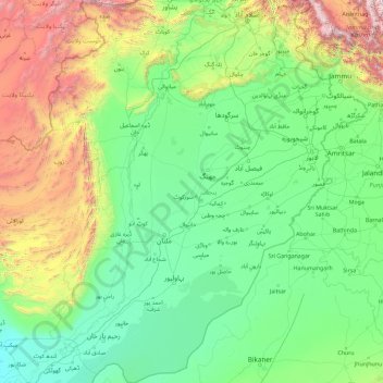
Name: Punjab topographic map, elevation, terrain.

Location: Punjab, Pakistan (27.70555 69.26176 34.01876 75.38148)

Average elevation: 623 m

Minimum elevation: 53 m

Maximum elevation: 5,045 m

Other topographic maps

Click on a map to view its topography, its elevation and its terrain.

Nanga Parbat

Pakistan > Gilgit-Baltistan > Astore District

To the south, Nanga Parbat has what is often referred to as the highest mountain face in the world: the Rupal Face rises 4,600 m (15,090 ft) above its base. To the north, the complex, somewhat more gently-sloped Rakhiot Flank rises 7,000 m (23,000 ft) from the Indus River valley to the summit in just 25 km (16…

Average elevation: 7,086 m

Kalyan

Pakistan > Punjab > Kasur District

Average elevation: 213 m

Hunza District

Pakistan > Gilgit-Baltistan

Average elevation: 4,510 m

Mansehra

Pakistan > Khyber Pakhtunkhwa > Mansehra District

Average elevation: 1,091 m

Islamkot Taluka

Pakistan > Sindh > Tharparkar District

Average elevation: 53 m

Mithi

Pakistan > Sindh > Tharparkar District

The town is located at 24°74'0N 69°80'0E with an altitude of 28 meters (92 feet). It lies 450 kilometers from Karachi and is located in a desert area. The geography of Mithi is characterized by its arid landscape, typical of the Thar Desert, which influences the climate, agriculture, and daily life in the…

Average elevation: 56 m

Ganz

Pakistan > Balochistan > Gwadar District > Jiwani Tehsil

Average elevation: 34 m

Jhang

Pakistan > Punjab

Jhang Sadr is located at 31.27 latitude and 72.33 longitude and is situated at an elevation of 158 meters above sea level.

Average elevation: 157 m

Faisalabad City Tehsil

Pakistan > Punjab

The soil consists of young stratified silt loam or very fine sand loam which makes the subsoil weak in structure with common kankers at only five feet. The course of the rivers within Faisalabad is winding and often subject to frequent alternations. In the rainy season, the currents are very strong. This leads…

Average elevation: 185 m

Islamabad

Pakistan > Islamabad Capital Territory

Islamabad is located at 33°26′N 73°02′E / 33.43°N 73.04°E / 33.43; 73.04 at the northern edge of the Pothohar Plateau and at the foot of the Margalla Hills in Islamabad Capital Territory. Its elevation is 540 metres (1,770 ft). The modern capital and the ancient Gakhar city of Rawalpindi form…

Average elevation: 666 m

Rawalpindi

Pakistan > Punjab > Rawalpindi District > Rawalpindi Cantonment

Rawalpindi features a humid subtropical climate (Köppen: Cwa) with hot and wet summers, a cooler and drier winter. Rawalpindi and its twin city Islamabad, during the year experiences an average of 91 thunderstorms, which is the highest frequency of any plain elevation city in the country. Strong windstorms…

Average elevation: 530 m

Khudian Khas

Pakistan > Punjab > Kasur District

Average elevation: 192 m

Khushab

Pakistan > Punjab

Average elevation: 193 m

Tawana

Pakistan > Punjab

Average elevation: 237 m

Talwara

Pakistan > Punjab

Average elevation: 244 m

Sibi

Pakistan > Balochistan > Sibi District

Average elevation: 170 m

Mouza Kund

Pakistan > Balochistan > Hub District

Average elevation: 6 m

Harnai

Pakistan > Balochistan > Harnai District

Average elevation: 966 m

Balochistan

Pakistan

Average elevation: 753 m

Kharfaq

Pakistan > Gilgit-Baltistan

Average elevation: 2,917 m

Karachi

Pakistan > Sindh > Karachi

Karachi lies very close to a major fault line, where the Indian tectonic plate meets the Arabian tectonic plate. Within the city of Karachi are two small ranges: the Khasa Hills and Mulri Hills, which lie in the northwest and act as a barrier between North Nazimabad and Orangi. Karachi's hills are barren and…

Average elevation: 20 m

Lahore District

Pakistan > Punjab

Average elevation: 213 m

Azad Kashmir

Pakistan

Average elevation: 1,728 m

Kot Duni Chand

Pakistan > Punjab

Average elevation: 218 m

Zone III

Pakistan > Islamabad Capital Territory

Average elevation: 659 m

Manawan

Pakistan > Punjab

Average elevation: 220 m

Nayi Ahbaddi

Pakistan > Azad Kashmir > Mirpur District

Average elevation: 243 m

Saddar Town

Pakistan > Sindh > Karachi South District

Average elevation: 4 m

Karakoram

Pakistan > Gilgit-Baltistan

Average elevation: 4,414 m

Samundri

Pakistan > Punjab

Average elevation: 174 m

Islamabad Capital Territory

Pakistan

The temperatures range from 13 °C (55 °F) in January to 38 °C (100 °F) in June. The hottest month is June, where average highs routinely exceed 38 °C (100.4 °F), while the coolest month is January. The highest recorded temperature was 46.6 °C (115.9 °F) on 23 June 2005 while the lowest temperature was…

Average elevation: 697 m

Mansoora Abad

Pakistan > Punjab

Average elevation: 187 m

Dharamkot

Pakistan > Punjab

Average elevation: 231 m

Gulistan-e-Jauhar

Pakistan > Sindh

Average elevation: 37 m

Muzaffargarh

Pakistan > Punjab

Average elevation: 121 m

Nazirabad

Pakistan > Sindh

Average elevation: 45 m

Taho

Pakistan > Azad Kashmir

Average elevation: 282 m

K-IV Canal

Pakistan > Sindh > Karachi

Average elevation: 100 m

Taxila

Pakistan > Punjab > Taxila Tehsil

Average elevation: 544 m

Nok Kundi

Pakistan > Balochistan > Chagai District

Average elevation: 683 m

Sandspit

Pakistan > Sindh > Karachi > کاکا پیر

Average elevation: 1 m

Sukkur

Pakistan > Sindh

Average elevation: 63 m

Chakwal

Pakistan > Punjab > Chakwal

Average elevation: 526 m

Jacobabad

Pakistan > Sindh > Jacobabad

Average elevation: 57 m

DHA Phase 4

Pakistan > Sindh > Defence

Average elevation: 12 m

Khunjerab Pass

Pakistan > Gilgit-Baltistan

Average elevation: 4,771 m