
Puebla topographic map
Click on the map to display elevation.
Puebla
Most of the mountains of Puebla belong to the Sierra Madre Oriental and the Trans-Mexican Volcanic Belt. The first is locally called the Sierra Norte del Puebla, entering the state from the northwest and then breaks up into the smaller chains of Sierra de Zacapoaxtla, Sierra de Huauchinango, Sierra de Teziutlán, Sierra de Tetela de Ocampo, Sierra de Chignahuapan and Sierra de Zacatlán, although these names may vary among localities. Some of the highest elevations include Apulco, Chichat, Chignahuapan, Soltepec and Tlatlaquitepec. The highest elevations are the volcanoes Pico de Orizaba or Citlaltepetl (5,747masl), Popocatépetl (5,452masl), Iztaccíhuatl (5,286masl) and Malinche (4,461masl) which are found on the state's borders with Veracruz, Mexico State and Tlaxcala respectively. In the south of the state, the major elevations are the Sierra de Atenahuacán, Zapotitlán, Lomerio al Suroeste and the Sierra de Tehuacán. Dividing much of the state from Veracruz is a small chain of mountains called the Sierra Madre del Golfo.
About this map
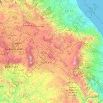
Name: Puebla topographic map, elevation, terrain.
Location: Puebla, Mexico (17.86091 -99.07049 20.83963 -96.72462)
Average elevation: 1,532 m
Minimum elevation: 0 m
Maximum elevation: 5,520 m
Other topographic maps
Click on a map to view its topography, its elevation and its terrain.
Mexico City
Mexico > Mexico City > Mexico City
Mexico City is located in the Valley of Mexico, sometimes called the Basin of Mexico. This valley is located in the Trans-Mexican Volcanic Belt in the high plateaus of south-central Mexico. It has a minimum altitude of 2,200 meters (7,200 feet) above sea level and is surrounded by mountains and volcanoes that…
Average elevation: 2,321 m
Monterrey
Mexico > Nuevo León > Monterrey
The city of Monterrey is 540 metres (1,770 ft) above sea level in the northeastern state of Nuevo León. Monterrey translated literally from Spanish to English is "King Mount" or "King Mountain", and folk etymology claims that this refers to the city's topography and the large mountains that surround it…
Average elevation: 753 m
Tijuana
Mexico > Baja California > Municipio de Tijuana
Housing development in the Tijuana Hills has led to eradication of many seasonal mountain streams. This lack of natural drainage makes places within the city vulnerable to landslides during the rainy season. The varied terrain of Tijuana gives the city elevation extremes that range from sea level to 790 meters…
Average elevation: 141 m
Morelia
Under the Köppen climate classification, Morelia has a subtropical highland climate (abbreviated Cwb on climate maps), with warm-to-hot days and cool nights year round due to its high elevation. Most precipitation falls during the summer monsoon season from June to September. Average monthly temperatures are…
Average elevation: 2,071 m
Guadalajara
Mexico > Jalisco > Guadalajara
Under the Köppen climate classification, Guadalajara has a humid subtropical climate (Cwa), a temperate climate that is quite close to a tropical climate, featuring dry warm winters and wet, mildly hot summers. Guadalajara's climate is influenced by its high altitude and the general seasonality of…
Average elevation: 1,572 m
San Luis Potosí City
Mexico > San Luis Potosi > Municipio de San Luis Potosí
San Luis Potosí, commonly called SLP or simply San Luis, is the capital and the most populous city of the Mexican state of San Luis Potosí. It is the municipal seat of the surrounding municipality of San Luis Potosí. The city lies at an elevation of 1,864 metres (6,115 feet). It has an estimated population…
Average elevation: 2,004 m
Cuernavaca
Mexico > Morelos > Cuernavaca
The city is located in a tropical region, but its temperature is fairly constant at 21–26 °C (70–79 °F). It is located on the southern slope of the Sierra de Chichinautzin mountains. In the morning, warm air flows up the mountains from the valley below and in the late afternoon, cooler air flows down…
Average elevation: 1,822 m
Ejido Rodolfo Sánchez Taboada
Mexico > Baja California > Municipio de Ensenada
Average elevation: 151 m
Francisco Zarco (Valle de Guadalupe)
Mexico > Baja California > Municipio de Ensenada
Average elevation: 384 m
Puebla
Mexico > Puebla > Municipio de Puebla
Most of its mountains belong to the Sierra Madre Oriental and the Trans-Mexican Volcanic Belt. The first is locally called the Sierra Norte del Puebla, entering the state from the northwest and then breaks up into the smaller chains of Sierra de Zacapoaxtla, Sierra de Huauchinango, Sierra de Teziutlán, Sierra…
Average elevation: 2,233 m
Toluca
Mexico > State of Mexico > Toluca
The Lerma River flows from Lake Almoloya del Río through the center of the municipality towards the west, flowing into Lake Chapala. From this point westward the river takes the name of Río Grande de Santiago. And it goes from this lake to the Pacific Ocean in the state of Nayarit. The river is about 1,180…
Average elevation: 2,729 m
La Paz
Mexico > Baja California Sur > Municipio de La Paz
The city, in west-central Bolivia 68 km (42 mi) southeast of Lake Titicaca, is set in a canyon created by the Choqueyapu River. It is in a bowl-like depression, part of the Amazon basin, surrounded by the high mountains of the Altiplano. Overlooking the city is the towering, triple-peaked Illimani. Its peaks…
Average elevation: 114 m
Puerto Vallarta
Mexico > Jalisco > Puerto Vallarta
Fourth: In 1968 the Puerto Vallarta municipality was elevated to City status. The elevation in status reflected interest by Mexican federal and state governments in developing the Puerto Vallarta as an international resort destination. Puerto Vallarta has since also attracted a lively immigrant community from…
Average elevation: 306 m
Acapulco
Mexico > Guerrero > Acapulco de Juárez
The city, located on the Pacific coast of Mexico in the state of Guerrero, is classified as one of the state's seven regions, dividing the rest of the Guerrero coast into the Costa Grande and the Costa Chica. Forty percent of the municipality is mountainous terrain; another forty percent is semi-flat; and the…
Average elevation: 99 m
Cerro El Coronel
Mexico > Chihuahua > Municipio de Chihuahua > Chihuahua City
Average elevation: 1,435 m
Ramos Arizpe
Mexico > Coahuila > Ramos Arizpe
Ramos Arizpe has a desert climate (Köppen climate classification BWh Owing to its altitude of 1,400 to 1,500 m (4,600 to 4,900 ft) above sea level, temperatures are milder than other desert cities at lower elevations. Winters are mild with warm temperatures during the day and cold nights. The January average…
Average elevation: 1,426 m
Ciudad Juárez
Due to its location in the Chihuahuan Desert and high altitude, Ciudad Juárez has a cold desert climate (Köppen: BWk). Seasons are distinct, with hot summers, mild springs and autumns, and cold winters. Summer average high is 35 °C (95 °F) with lows of 21 °C (70 °F). Winter highs average 14 °C (57 °F)…
Average elevation: 1,228 m
Oaxaca City
Mexico > Oaxaca > Oaxaca de Juárez
Oaxaca has a tropical savanna climate (Köppen climate classification Aw), closely bordering on a humid subtropical climate (Cwa), due to its high altitude. During the dry season, temperatures during the day remain warm with an average high of 27.1 °C (80.8 °F) in the coolest month, December, and an average…
Average elevation: 1,838 m
Guadalajara
Mexico > Jalisco > Guadalajara
Under the Köppen climate classification, Guadalajara has a humid subtropical climate (Cwa), a temperate climate that is quite close to a tropical climate, featuring dry warm winters and wet, mildly hot summers. Guadalajara's climate is influenced by its high altitude and the general seasonality of…
Average elevation: 1,572 m
Mirador de Cuatro Palos
Mexico > Querétaro > Pinal de Amoles > Cuesta Colorada > Maguey Verde
Average elevation: 2,304 m
Morelia
Under the Köppen climate classification, Morelia has a subtropical highland climate (abbreviated Cwb on climate maps), with warm-to-hot days and cool nights year round due to its high elevation. Most precipitation falls during the summer monsoon season from June to September. Average monthly temperatures are…
Average elevation: 2,071 m
Monterrey
Mexico > Nuevo León > Monterrey
The city of Monterrey is 540 metres (1,770 ft) above sea level in the northeastern state of Nuevo León. Monterrey translated literally from Spanish to English is "King Mount" or "King Mountain", and folk etymology claims that this refers to the city's topography and the large mountains that surround it…
Average elevation: 753 m
Isthmus of Tehuantepec
At its narrowest point, the isthmus is 200 km (124 mi) across from gulf to gulf, or 192 km (119 mi) to the head of Laguna Superior on the Pacific coast. The Sierra Madre del Sur mountain range breaks down at this point into a broad, plateau-like ridge, whose elevation, at the highest point reached by the…
Average elevation: 277 m
Puebla
Mexico > Puebla > Municipio de Puebla
The Sierra del Tentzon and higher elevations of Malinche volcano still conserve the Trans-Mexican Volcanic Belt pine-oak forests ecoregion – with forests of pine, holm oak and other tree species. In the pine forests, Montezuma Pine (Pinus montezumae) is generally predominant, with Hartweg's Pine (Pinus…
Average elevation: 2,233 m
Saltillo
El Cerro del Pueblo (The People's Hill) and its 4-metre (13 ft) cross overlook the city. The city's elevation makes it colder and windier than the neighboring city of Monterrey. Saltillo lies in the Chihuahuan Desert near the city of Arteaga. The city is flanked by the Zapalinamé mountains, which are part of…
Average elevation: 1,857 m
Tepotzotlán
Mexico > State of Mexico > Tepotzotlán
The municipality, founded in 1814, is bordered by the municipalities of Huehuetoca, Coyotepec, Cuautitlán Izcalli, Nicolás Romero, Teoloyucan and Villa del Carbón as well as the State of Hidalgo with a total area of 208.8 km2 (80.6 sq mi). The municipality varies in altitude from 2,250 to 2,900 meters…
Average elevation: 2,309 m
Tijuana
Mexico > Baja California > Municipio de Tijuana
Housing development in the Tijuana Hills has led to eradication of many seasonal mountain streams. This lack of natural drainage makes places within the city vulnerable to landslides during the rainy season. The varied terrain of Tijuana gives the city elevation extremes that range from sea level to 790 meters…
Average elevation: 141 m
Rosarito
Mexico > Baja California > Municipio de Playas de Rosarito
Playas de Rosarito lies on the coast of the Pacific Ocean on the North Baja California Peninsula. The city is positioned between the foothills of the Peninsular Ranges and the ocean. It maintains a relatively uniform topography and displays few variances in terrain.
Average elevation: 103 m
Toluca
Mexico > State of Mexico > Toluca
Toluca is located at 2600 meters above sea level, being the highest capital city in Mexico and North America, which makes it temperate throughout the year with average temperatures ranging between 6 and 25 degrees Celsius during spring and summer, and from −5 to 20 degrees Celsius in winter. Its climate is…
Average elevation: 2,729 m
Monterrey
Mexico > Nuevo León > Monterrey
The city of Monterrey is 540 metres (1,770 ft) above sea level in the northeastern state of Nuevo León. Monterrey translated from Spanish to English is "King Mount" or "King mountain", which refers to the city's topography and the large mountains that surround it. The Santa Catarina River—dry most of the…
Average elevation: 753 m
Pico de Orizaba
Mexico > Puebla > Chalchicomula de Sesma
Citlaltépetl (from Náhuatl citlal(in) = star, and tepētl = mountain), otherwise known as Pico de Orizaba, is an active volcano and the highest in North America, as well as the highest mountain in Mexico and third highest peak in North America, after Denali/Mount McKinley of the United States and Mount Logan…
Average elevation: 4,969 m
Chilpancingo
Mexico > Guerrero > Chilpancingo de los Bravo
The climate of Chilpancingo is classified as a tropical savanna climate ("Aw"). There is some moderation due to high elevation, but high temperatures are still in the upper 20s °C (80s °F) for most of the year.
Average elevation: 1,627 m
San Miguel de Allende
Mexico > Guanajuato > San Miguel de Allende > San Miguel de Allende
Average elevation: 2,029 m
Tepic
Located in the central part of the state, it stands at an altitude of 915 metres (3,002 ft) above sea level, on the banks of the Río Mololoa and the Río Tepic, approximately 225 kilometres (140 mi) north-west of Guadalajara, Jalisco. Nearby are the volcanoes of San Juan, Las Navajas, and Sangangüey. Tepic…
Average elevation: 921 m
Ciudad Mante
Mexico > Tamaulipas > El Mante
El Cielo (The Heaven) a protected cloud forest covers a land mass of 144,530 hectares (~357,129 acres) and is a paradise for the great quantity of species that inhabit it. There are 175 distinct species of migratory birds and 225 local fowl, various amphibious and mammals, as well as white tail deer, jaguar…
Average elevation: 105 m
Popocatépetl
Mexico > Puebla > Tochimilco
According to paleomagnetic studies, the volcano is about 730,000 years old. It is cone shaped with a diameter of 25 km (16 mi) at its base, with a peak elevation of 5,450 m (17,880 ft). The crater is elliptical with an orientation northeast-southwest. The walls of the crater vary from 600 to 840 m (1,970 to…
Average elevation: 4,807 m
Zapopan
Most of the municipality is flat with another quarter having rolling hills. Altitude varies from 1,500 to 2,000 metres (4,900 to 6,600 ft) above sea level. The main elevations are in the Sierra de la Primavera and include Nejahuete, Tajo and El Chapulin. Superficial water flows mostly in arroyos east to the…
Average elevation: 1,598 m
Saltillo
El Cerro del Pueblo (The People's Hill) and its 4-metre (13 ft) cross overlook the city. The city's elevation makes it colder and windier than the neighboring city of Monterrey. Saltillo lies in the Chihuahuan Desert near the city of Arteaga. The city is flanked by the Zapalinamé mountains, which are part of…
Average elevation: 1,857 m
Cuernavaca
Mexico > Morelos > Cuernavaca
The city is located in a tropical region, but its temperature is fairly constant at 21–26 °C (70–79 °F). It is located on the southern slope of the Sierra de Chichinautzin mountains. In the morning, warm air flows up the mountains from the valley below and in the late afternoon, cooler air flows down…
Average elevation: 1,822 m